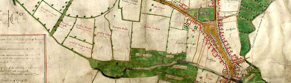
Favourite ERO documents: Walker map of Chelmsford, 1591

As well as asking our users about their favourite documents from our collections, we have also been asking ourselves. Here Public Service Team Manager Neil Wiffen tells us about his favourite document, John Walker’s 1591 map of Chelmsford.

 My favourite document at the ERO has to be one of the best known and most widely reproduced – the 1591 Walker map of Chelmsford. This might be an obvious choice (and could it be said boring?) but for me it works on so many levels.

Extract from the Walker map of Chelmsford, 1591 (D/DM P1)

Extract from the Walker map of Chelmsford, 1591 (D/DM P1)

First of all it is a map and I think everyone likes a map because we can all get something from a map so very easily. We don’t need to read Latin or funnily written handwriting to be able to enjoy an historic map. As maps go it is a sumptuous and artistic map. The colours are still so very vivid even after 422 years and the wonderful portrayal of the buildings by John Walker is exquisite.

Being Chelmsford born and bred it works for me on a local level, a source of civic pride. I can’t help when I walk down the High Street but try and imagine what it would have been like when Walker surveyed the town. Indeed walking down the High Street is to walk in our predecessors footsteps so little has the basic layout of the town changed over the centuries. In a way the map is the nearest we can ever get to late Tudor Chelmsford, so it allows us to travel in time. It is a map that continues to keep me thinking about town development. If ever you’ve been shopping on a Friday or Saturday when they have the market stalls in the High Street you can just imagine what it was like when the Middle Row was developed over centuries. Stall holders didn’t bother to take down their stalls overnight but slept under the counter or added another level and before you knew there was a row of permanent shops which Walker depicts.

It can also be a dangerous map as well. Looking at the layout of Chelmsford in 1591 we can be lulled in to thinking how much nicer it would be to live in a small Chelmsford. Urban development and awful planning decisions of the 1950s-70s have deprived the town of much interest which is there in the Walker map. However, we must not forget the appalling inequality, insanitary conditions and harsh punishments of those earlier centuries.

Last of all it is a map of wonder. How did John Walker survey the town and produce the map? Whenever I look at the map I always think – ‘John Walker, what a clever bloke!’

If you would like to nominate your own favourite ERO document, we would love to hear from you. Simply download this form, and return it to the Searchroom desk or by e-mail to hannahjane.salisbury[at]essex.gov.uk. There are also paper copies available at the Searchroom desk. Nominated documents may be featured on this blog or in displays at our open day on Saturday 14 September 2013.

Could this be our smallest document?

D/DLu 17/6 is definately very small.

D/DLu 17/6 is definitely very small.

D/DLu 17/6 measures just 36 x 26 mm and is so small that we have had to construct a special folder to keep it safe and to make it harder to lose.

D/DLu 17/6 in its specially made folder.

D/DLu 17/6 in its specially made folder.

All wrapped up and ready to go back into storage. The larger folder certainly makes it easier to keep track of.

All wrapped up and ready to go back into storage. The larger folder certainly makes it easier to keep track of.

 D/DLu 17/6 is a tiny sketchbook created by Clarissa Sandford Bramston [née Trant] who was married to the Reverend John Bramston from 1832 (vicar of Great Baddow, 1830-40; vicar of Witham, 1840-72; Dean of Winchester, 1872-1883). It is impossible for us to know when the document itself was created other than to say it must have been created before 1844 when Clarissa died. Perhaps someone with a strong magnifying glass and an interest in Essex architecture may be able to suggest a date?

IMG_1095v

Galleywood Chapel which pre-dated the church before it was a parish in its own right.

The sketches show several churches, chapels and houses of Essex and a rather attractive view of Danbury, all in a surprising amount of detail for its diminutive size.

A view of Danbury.

A view of Danbury.

Alongside this miniature sketchbook, Clarissa also left us several other documents of more reasonable size, including her journals and diaries running from 1800 right up until her death in 1844 and numerous other scrapbooks, recipes and items of correspondence, all of which are part of the Luard and Bramston deposit (catalogued as D/DLu).

Billericay High Street in 1950s photographs

We have recently had deposited with us a series of 146 photographs taken (for uncertain reasons) by the RAF of Billericay High Street in the 1950s (A13652 Box 1).

The High Street was systematically photographed, and the images include residences, local businesses, chain shops, pubs, and people. The full set of photographs can be ordered to view in the Searchroom, but you can see below for a few sneak previews.

42 High Street & 1-3 Chapel Street

42 High Street & 1-3 Chapel Street – Goodspeeds fish and caterers

61, 59 & 57 High Street

61, 59 & 57 High Street – E. Smith, family butcher

63 High Street

63 High Street – J.E. Morris, Off Licence

88 & 90 High Street

88 & 90 High Street, W.H. Iles Estates Ltd and Bata shoes

89 High Street

97-95 High Street

97-95 High Street – Essex County Library and Slade’s boot and shoe repairs

101 High Street

101 High Street – Woolworths