A Mappa Monday

Customer Service Team Lead, Edward Harris, looks at the highs and lows of research using our manuscript map collection.

We may have said before that we love maps here at ERO. But some of our manuscript maps can leave you scratching your head.

We have often ordered up something titled “Map of the Parish of…”, hopeful that it will give us an extensive view of the parish in question, only to get something like D/DWe P5 below. A map of Bagg Wood belonging to Thomas White Esq surveyed in 1703.

Map of Bagg Wood in Aldham

Map of Bagg Wood in Aldham (D/DWe P5)

These maps may show one or more field with very little context and no real clue of where it is. We do at least know that it is in Aldham and which part of the ditch it was measured to!

Examining a Google maps satellite images leaves us with scant help. While many of the woodlands do reveal a name when clicked on, none of them are named Bagg Wood. A perusal of the National Library of Scotland’s excellent Geo-referenced map resource (https://maps.nls.uk/) reveals only one candidate that is roughly the right shape, but called Hoe Wood on the 2nd Edition 25” to the mile Ordnance Survey. I suppress a little frustration that the surveyors in the late 1880s didn’t include an acreage as they had done in the 1870’s.

The perfect next step was our collection of copy Tithe Maps. Listing the owner, occupier, acreage and cultivation of every plot of land in the parish, but often also the names of houses, fields and woodland.

The Tithe Map of Aldham, surveyed in around 1839 (D/CT 2B) and it’s accompanying Award (D/CT 2A) is wonderfully clear and easy to consult, but it is also clear that there is no Bagg Wood. What is however, is a vast array of land owned by a Thomas Western, the major landowner in Aldham. One plot of land is the aforementioned Hoe Wood with an Acreage of 21 Acres 2 Roods and 21 Perches. Close enough?

Tithe map of Aldham 1843 (D/CT 2B)

Then I realised that I had fallen for yet another pitfall of a manuscript map, North is not always at the top of the page. A quick 90 degree counter-clockwise rotation of the parchment revealed the North is actually to the right hand edge of the map, and Bagg Wood and Hoe Wood are one and the same.

To add to the clues, the “DWe” part of the maps reference, tells me that it is part of the papers of the Western family.

Manuscript maps are often less clear even than this one, half the fun is in trying to locate their features on a modern map. Manuscript maps can be beautiful. Having a set of maps beautifully crafted for your estate was the status symbol of its day.

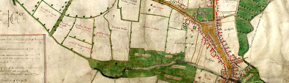
By way of example, here is another estate map for the estate of Thomas Western. D/DCm P29 dating to 1809 and surveyed by Robert Baker meticulously records all of the estate over several membranes and is beautifully decorated.

The value of this volume of estate maps can be seen in the gold leaf and beautiful colours used. It has also been separated from the other family papers at some point which can be seen by the different reference. Was this because it was sold off at some point to raise some vital funds? Can you spot Bagg Wood? Also, bonus points if you spotted the route of the railway marked across the estate.

D-DCm P29 Plan

Plan of the Estate of Thomas Western (D/DCm P29)

Document of the Month, September 2018: survey of Rivenhall

New fragments which tell us about Essex’s past come in to us all the time, in all shapes and sizes. Here, Archivist Ruth Costello tells us about one of our new additions – a beautiful survey of the Rivenhall estate. The volume bears no date, so Ruth has been sleuthing to see if she could find out when it was made.

This month’s document is one of two volumes of maps which we received earlier this year as part of accession A14956. This, the smaller of the two, shows Rivenhall Place and its lands, which were owned by the Western family.

The index at the beginning of the volume lists the parts of the Rivenhall estate which are included in the survey

For each part of the estate, there is a carefully drawn map, and a list of how each parcel of land was being used. This map shows Rivenhall Place and the lands immediately around the grand house.

Despite its undoubted beauty, it seems to have been treated as a working document, with annotations in pencil, some of which seem to have been rubbed out at a later date.

Unfortunately, the survey does not include a title page, where we might expect to find the name of the surveyor.  Nor does it include a date.

We knew the volume must predate 1839 as the Rivenhall tithe map produced in that year clearly shows the newly built Eastern Counties Railway running through the parish.  In the volume, it has been pencilled in at a later date (it’s the line crossing through the meadow land numbered ‘23’, north of Rivenhall End in the page on display).

The two lines marked in pencil through field no. 23 on this map show where a railway line was later built, helping us to date the volume

We already held two maps of Rivenhall Place among the Western family estate records drawn in 1828 and 1839 (this latter one didn’t show the railway, so must have been produced earlier that year).  It’s unlikely that the land would have been surveyed and mapped on another occasion, so we thought that the volume must tie in with the date of one of these maps.

On display in the ERO Searchroom, the volume is opened to display the map of Pond Farm, which at the time was leased (somewhat appropriately) by Joseph Lake.  Both the volume and the 1828 map (D/DWe P12) show a property described as ‘workhouse land’ (it’s surrounded on two sides by the field numbered ‘26’).  The later map of 1839 (D/DWe P16) has the name ‘Bilney’ against this property.  It would seem that Mr Bilney bought the property after the Poor Law Amendment Act of 1834 led to the sale of former, smaller parish workhouses and the creation in this case of the new Witham Poor Law Union workhouse.

Map of lands that made up Pond Farm

List of lands making up Pond Farm

Some of the surrounding area is described as ‘William Blackborne’s land’.  We found a burial for a William Blackborne in the Rivenhall parish register in 1825.  Initially this made us think that the volume must predate his death and must be earlier than 1825.  However, both the 1828 and 1839 estate maps also included his name, which showed that out of date information was being copied forwards.

We think, therefore, that the volume and the 1828 map we already held were drawn at the same time.  Sadly, we still don’t know who drew them; the map also has no author.  The map shows the whole of the estate and its individual farms together, but it has only a very little colouring, by comparison with the volume.  This volume and its companion (a series of maps of the Felix Hall estate) are thus a welcome addition to our holdings.

The volume will be in display in the Searchroom throughout September 2018.

In search of Messing Hall: an adventure in old maps

We are in the midst of preparing for our next ‘on the map’ outreach event, which will take place in the village of Messing near Tiptree on Saturday 19 March 2016. We have done a few of these events in different locations around the county, taking a timeline of maps from our collection out for a special pop-up display.

One of the maps we will be taking with us on this occasion is this 1650 map showing the lands of Messing Hall (D/DH P1).

Map of Messing, 1650

‘A survey of all the lands appertaineing to Messing Hall in the county of Essex with the number of acres the wch was surveyed by William Bacon and Benedict Coule’ (D/DH P1)

Messing Hall itself is shown to the east of the village centre as a very grand moated building, with a farm to the north.

The map is part of a collection of papers relating to the Luckyn family of Messing. Sir Capel Luckyn acquired the estate of Messing Hall in 1650, so presumably he commissioned the map as he took possession of his grand new property.

The map makes an immediate visual impact, but on closer inspection bears only a passing resemblance to the actual layout of Messing – cue ERO staff members scratching their heads and poring over maps, aerial photos and any histories of Messing we could get our hands on, trying to work out what the 1650 map actually showed us.

Trying to work it all out

Trying to work it all out

Ordnance Survey map of Messing, 1874

The 6″ : 1 mile Ordnance Survey map of 1874

To begin with it all seemed a confusing mess. While the 1650 map shows the grand Messing Hall on a road heading east out of the village, the Ordnance Survey map of 1874 shows that there is no such road, leaving us with a mystery to solve – where was Messing Hall? The representation of it on the map no doubt blows the size of the house out of all proportion, but clearly an important property existed and we could find no obvious sign of it on any later maps.

There were two main candidates for the site – Harborough Hall, to the south of the village, and Messing Lodge, to the north.

Our sights first landed on Harborough Hall – it was the closest substantial property to the village, and sits on a bend in the road, as does the property on the 1650 map. We read that the manors of Messing and Harboroughs merged in the 1400s, so perhaps the names had been used interchangeably.

Messing Lodge, meanwhile, just seemed too far from the village and too far north. Could the 1650 map really be that inaccurate?

We hunted for anything that would help us tie up the things represented on the 1650 map with more accurate later maps.

Our first breakthrough came from matching up Oynes Brook, shown on the 1650 map, with Domsey Brook shown on later maps. Once we had found the brook, we were able to match up the forked road shown in the 1650 map to the north of Messing Hall with the fork shown in later maps above Messing Lodge. Although not quite the same shape, on both maps one fork crosses the brook (and stops short just after it), and the other fork becomes ‘Easthop way’ or ‘Easthorpe Road’. There are also water features on the 1897 map which could relate to the moat shown in 1650.

Portion of the 1650 map showing Messing Hall compared with 1897 map showing Messing Lodge

Portion of the 1650 map showing Messing Hall compared with 1897 map showing Messing Lodge

This was pleasing evidence, and was further supported by some of the field names surrounding the property.

Fields named 'Charcums' near Messing Hall

Fields named ‘Charcums’ near Messing Hall

The 1650 map shows ‘Great Charcums’, ‘Charcum meadow’ and ‘Charcums spring’ to on the opposite side of the road to Messing Hall. On the tithe map of 1839, fields near to Messing Lodge are known as ‘Little Chalkhams’ and ‘Great Chalkhams’.

With the evidence of the brook, the fork in the road, the road to Easthorpe and the Charcum/Chalkhams field names, we think we have a satisfactory answer to our mystery, and we can put Messing Hall back on the map.

One of the joys of research is problem solving, and the excitement when things finally fall into place, especially when you can share that joy with fellow researchers.

Fortunately for the 1650 map, what lacks in accuracy it makes up for in exuberance. Come along to see it for yourself at Messing about with Maps on Saturday 19 March at Messing Village Hall.


Messing about with Maps

A chance to see historic maps of Messing kept at the Essex Record Office in Chelmsford, including a hand-drawn map from 1650 and the Messing tithe map of 1839.

Saturday 19 March, 10.30am-3.00pm

Messing Village Hall, The Street, Messing, CO5 9TN

Just drop in, suggested donation of £2.00