Harlow Housing and Design Interviews Online

Harlow New Town was established in 1947, when the New Town Development Corporation began to purchase land around the old town and erect new housing estates. The houses primarily served to relieve housing pressures on bombed-out, overcrowded London, particularly from the East End. The first residents began moving in from 1949.

So say the textbooks, but what personal stories lie behind these brief facts? At the Essex Sound and Video Archive, we hold a wonderful collection of oral history interviews conducted by Dr Judy Attfield in the 1980s for her research project, Harlow Housing and Design (SA 22). These interviews reveal what it was like to live in the new town. Our Heritage Lottery Funded project, You Are Hear: sound and a sense of place, has enabled us to digitise all of the original cassettes and make them freely available through Essex Archives Online.

Screenshot of SA 22 catalogue

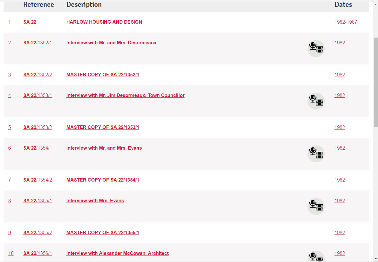
A satisfying sight: the icons show that there is audio material attached to that catalogue entry.

At first, we thought the digitisation would be a straightforward task. Shortly after the collection was first deposited with us in 1996, we created access copies on cassette, to safeguard the original masters (our standard procedure in the Sound Archive). The access copies are all neatly labelled and clearly identified, one cassette per interview.

However, when we looked in the box containing the original cassettes, things were not quite so straightforward. We digitise from the original recording (or as near to the original recording as we can get), to capture the purest sound. On revisiting the masters, we realised that the interviewer had used one cassette for multiple interviews – a common practice when you want to make the most of the cassette tape you have. Piecing each recording together to make one complete interview has caused our digitiser, Catherine Norris, several headaches.

But now they are all digitised. Similar to our procedure with physical analogue recordings, we keep a master, uncompressed .wav file safely in storage. We then create compressed .mp3 copies as our new access copy. You can still come into the Searchroom and listen to the recordings, but you can also now listen from home, through Essex Archives Online.

Each interview is valuable in its own right, but as a collection it is even more fascinating. Dr Attfield spoke to a range of people: developers, architects, and town councillors who shed light on the planning of the new town; shopkeepers; people who moved to Harlow before the new town; and people who moved as part of the new town settlement. Putting these different viewpoints together gives a rich, rounded impression of this time in history. Some interviewees say that women found it more difficult than men to settle in new towns and felt lonely and depressed; some say that women found it easier to form new bonds because they were surrounded by women in a similar position, raising children away from their parents in unfamiliar surroundings. Some were ecstatic to have their own front doors, their own staircases in two-storey homes; some missed the familiarity of London, even if they were living in cramped, shared housing. The multiplicity of memories challenges generalisations about life in a new town. It also demonstrates (by listening to the accents of the interviewees, if nothing else) that not everyone in Harlow in the 1950s was an ex-Eastender.

The collection also serves as a good example of how to conduct an oral history interview. Dr Attfield had a specific interest in the interior design of the new houses. She directed questions to gather information on this topic. However, she also asked wider questions for context. She let her interviewees say what they wanted with minimal interventions, but also guided the interview to cover her set of questions. Occasionally she probed her interviewees for more details, or challenged their viewpoints to get a better understanding, without revealing any judgement of their opinions.

Dr Attfield made a significant research contribution in the fields of material culture, gender studies, and design history, among other overlapping areas. Based for many years at the Winchester School of Art, her book Wild Things: The Material Culture of Everyday Life (Oxford: Berg, 2000) has become a key text in her field. She passed away in 2006. We are very grateful that she deposited her recordings about Harlow with us, for future researchers to use and enjoy.

One particularly moving interview from the collection is that with Mrs Summers, who moved to the new town from Walthamstow in 1952 (SA 22/1364/1). At several points in the interview, Mrs Summers describes the long adjustment period when ‘home’ still meant London before completely settling in Harlow. As well as missing her family, in this clip she describes how she ‘couldn’t get used to the newness of things’ after coming from Walthamstow with its ‘houses with big windows… little tiny houses… nice houses… [and] grubby-looking houses’.

At a time when neighbourhood plans for vast numbers of additional houses are being developed across Essex – across the country – perhaps these experiences of new settlers can help with the process of creating new communities.

Dr Attfield published an article based on these interviews in the book that she co-edited with P Kirkham, A View from the Interior: Women and Design (London: Women’s Press, 1995). The article can be consulted at Colchester Library.

We hope to showcase clips from these recordings on a listening bench in Harlow, in time for the 70th anniversary of the New Town in 2017. If you are interested in helping to work on the bench for Harlow, please get in touch: info@essexsounds.org.uk

Colchester then and now: The Ichnography of Colchester

Regular readers will probably have noticed our Chelmsford Then and Now series of blog posts, written by Ashleigh Hudson, who worked with us on a research placement last year as part of her MA degree with the University of Essex. We have been fortunate this year to have hosted another student placement, and this year Louise Rodwell has been investigating the history of the High Street of Britain’s oldest recorded town, Colchester. We will be sharing the results of her research here over the coming months. You can also join us at Colchester on the Map on Tuesday 15 November 2016 at Colchester Town Hall to see some of our historic maps and photographs from the town.

In his 1825 History of Colchester, the antiquarian Thomas Cromwell wrote that ‘To every lover of history and antiquarian research, there can exist few more interesting towns than that of Colchester’.

‘Perspective view of Colchester in the County of Essex’, engraved for The Complete English Traveller (I/Mb 90/1/)

‘Perspective view of Colchester in the County of Essex’, engraved for The Complete English Traveller (I/Mb 90/1/)

Colchester is well known as a Roman town, but much less is popularly known about the other phases of its history, despite its involvement with events such as the Dutch Revolt, which resulted in an influx of Dutch and Flemish migrants to the town, the English Civil War, when Colchester was besieged, and the witch trials of East Anglia, led by the notorious Matthew Hopkins.

This project sets out to explore the histories of selected sites on Colchester High Street, and to imagine the lives of some of the people who have lived, worked, shopped and walked along this historic road. Using maps, documents and photographs from the Essex Record Office, this research will investigate continuity and change in the high street, and reflect on how Colchester’s past shapes our experience of the high street today.

To get us started, we thought we would take a look at one of our favourite maps of the town, which provides a fabulous window into the past.

This survey, grandly headed ‘The Ichnography of Colchester’ (MAP/CM/25/1), dates from about 1748. It is unsigned, but is believed to be by a man named James Deane, a local architect from whom we also have other records and drawings. The unusual word ‘ichnography’ is an architectural term with Greek origins, usually used to mean a ground plan of a building, but here used to mean a plan of a whole town. The layout of the town seen here is easily recognisable today, and is based on the streets set out by the Romans.

James Deane’s plan of Colchester, c.1748 (MAP/CM/25/1)

James Deane’s plan of Colchester, c.1748 (MAP/CM/25/1) (Click for a larger version)

No scale is given, but it is approximately 1:2,800. The map is dedicated to the Hon. Philip Yorke and his Consort The Lady Marchioness of Grey; Yorke was Earl of Hardwicke, a local landowner and MP for Reigate and later Cambridgeshire.

Some streets are named on the map, while others are included in a key which lists 41 places indicated on the map by letters and numbers. These include places still familiar to us today, such as the castle, St John’s Abbey Gate, the high street and Head Street, and other names which have fallen out of use, such as Grub Street, Hog Street and Cat Lane. Grub Street, labelled ‘a’, was the short bit of road connecting St Botolph’s Street with Magdalen Street.* Hog Street is in the south east of the map, and possibly is what today is known as Military Road, while Cat Lane has been upgraded to become Lion Walk.

This is a map that rewards detailed study, with a number of charming details to spot. A few of our favourites are middle row, a narrow row of shops and a church in the middle of the High Street, none of which still exist today, ships sailing on the River Colne at the Hythe in the south east corner of the map, and the three windmills shown on the southernmost edge of the map.

Middle row, including St Runwald's church (MAP/CM/25/1)

Middle row, including St Runwald’s church (MAP/CM/25/1)

Ships on the Hythe (MAP/CM/25/1)

Ships on the Hythe (MAP/CM/25/1)

Three windmills on the southernmost edge of Deane's map (MAP/CM/25/1)

Three windmills on the southernmost edge of Deane’s map (MAP/CM/25/1)

In our future blog posts in this series we will be looking at a series of properties along the high street which reflect different aspects of town life and how it has changed through the centuries, including pubs, inns, churches and shops.

In the meantime, do join us on Tuesday 15 November at Colchester Town Hall to see James Deane’s map alongside several others of the town, along with historic photographs and sound recordings, at Colchester on the Map.

*This part of the blog post was corrected on 17/11/16 after a reader flagged up that we had made an error in our original identification of Grub Street as Balkerne Hill.

Essex Archives Online update – digitising our electoral registers

We have just begun the next big expansion of digitised records available through our subscription service on Essex Archives Online, with the beginning of our project to provide digital images of our electoral registers.

There are some 850 volumes in our collection of Essex electoral registers

There are some 850 volumes in our collection of Essex electoral registers

Ultimately we will be making available images of all the registers we hold from 1833-1974. The first phase of the project has just been completed, with digital images of our electoral registers from 1833-1868 now all available online. We will be releasing the images in batches, with a target completion date for the whole project of January 2018.

(There is a little caveat to this – the registers for 1918 and 1929 have been online for some time, and they will of course remain.)

While our set of Essex electoral registers is not 100% complete, it is the best surviving set of these records, and for some registers ours is the only surviving copy. This collection of some 850 volumes provides vital evidence of Essex people’s lives and locations over almost 150 years.

As with the images of Essex parish registers and wills already available online, the images of the electoral registers can be viewed free of charge in the ERO Searchroom, or as part of our online subscription packages. Information about how to find the records and how to subscribe can be found on our subscription home page.

Electoral register page for Bardfield Saling, 1851 (Q/RPr 1/10)

Electoral register page for Bardfield Saling, 1851 (Q/RPr 1/10)


Why digitise electoral registers?

There are two key drivers for digitising these records: 1, to make them more widely available, and 2, to preserve the originals. Electoral registers were not designed to have a long lifespan and can be somewhat fragile. As popular records they are frequently in demand, and digitisation allows us to make the information available while protecting the original documents.


How will the records be indexed?

As with the parish registers already available in Essex Archives Online, we are not publishing a name index, but all of the registers in this batch are arranged alphabetically – that is, electors appear in each parish in alphabetical order of surname.  This makes tracing individuals fairly easy.  In addition, each register is indexed by parish or place, and they offer great opportunities not just for family historians but also for studies of local society and urban development.  An annual list of the main property owners and occupiers in each place is a valuable addition to the online record, particularly where the local rate books (the ultimate source of much of this information) fail to survive.


Why do the records start in 1833?

Modern electoral registers came into being with the Great Reform Act of 1832.  The Act did not hugely increase the electorate, but for the first time it required the Clerk of the Peace – the head of the county administration – to have the annual parish lists of electors’ names ‘fairly and truly copied … in a book to be by him provided’, and to give to each elector’s name ‘its proper number, beginning the numbers from the first name’.  That book would be the electoral register for the following year. The Clerk was not required to print the registers, or to preserve them once the year was out, and before the mid-1840s only two survive in Essex. After that matters steadily improve, and from the early 1860s until 2001 the Record Office’s collection is fairly complete.


Who will be included in these registers?

The 1832 Reform Act expanded the electorate to some extent, but it was still limited to men aged over 21 who owned a certain amount of property. In 1851 just 11,500 county electors spoke for an Essex population of almost 370,000.

By no means all the electors for a particular parish actually lived there, or even close by, and their actual places of residence can be revealing. In 1851 the divided freehold of the King’s Head Inn at Gosfield, in the northern division of Essex, provided the qualification for 6 of the parish’s 13 electors. One lived in Chelmsford, one in Great Yarmouth in Norfolk, one in London and three in Surrey.

At Braintree, three brothers from the Buxton brewing family each held a vote in respect of Hyde Farm, the farm’s ownership being split between them. According to the register, however, Sir Edward North Buxton Bt. – who was in fact the MP for South Essex – lived in Upper Grosvenor Street, Mayfair; Charles Buxton lived near the brewery in Brick Lane, Spitalfields, Middlesex; and Thomas Fowell Buxton lived in Leytonstone (Leyton), which was at least in Essex at the time, although far away in the southern division.

At Leyton, the pattern was repeated and each of the brothers qualified once more, this time through the freehold of the Three Blackbirds inn – although Thomas Fowell Buxton had apparently forgotten that he lived in the parish and gave the Spitalfields address as his place of residence.  For researchers into Victorian society, and especially the connections between land and politics, electoral registers are a mine of information.

For family historians, the names of the electors will naturally be the focus of interest, although the electors themselves are not the only people named.  For example, William Wing of Bloomsbury in London had a vote in 1851 for his house in Braintree on ‘corner of square, Miss Wing, tenant’.  She, of course, had no vote at all – but the naming of such voteless tenants increases the registers’ value to historians.  Miss Wing is known from the 1851 census as Sarah Wing, a silversmith and watchmaker living and working in Great Square, and census users might well have wondered about a possible connection with William Wing, born in Braintree but working as a watchmaker in New Bond Street in London.  Despite the gap between New Bond Street and Braintree, the electoral register evidence makes their connection almost certain, and suggests something of Sarah and William’s family arrangements.  Linking the electoral registers to other sources makes the whole data set much more powerful.


How did elections take place in this period?

The process of electing MPs in the 1830s-1860s was quite different to today. There were two different kinds of constituencies – counties and boroughs. The theory was that county MPs would represent landholding interests, and borough MPs the interests of the mercantile and trading classes. Before 1832 Essex sent 8 MPs to Parliament – 2 from the county seat of Chelmsford, and 2 each from the ancient boroughs of Colchester, Maldon and Harwich.

Before 1832 there was enormous variety in the size of constituencies and in voting qualifications. Polling could last up to 40 days, and there was no secret ballot. The whole system was liable to corruption and domination by local elites.

The 1832 Reform Act went some way towards resolving some of these issues. Most rotten boroughs (boroughs with tiny electorates controlled by a wealthy patron) were abolished, and seats were redistributed to growing industrial towns. Polling was limited to two days, and the qualifications for the franchise were standardised.

Essex gained two more MPs as part of the changes as the county constituency was split into two divisions, north and south, each returning two MPs, in addition to the two each still returned from the three ancient boroughs.

Flyer by John Gurdon Rebow of Wivenhoe Park, who stood as an independent candidate for North Essex in the 1847 general election. The policies he outlines here include the protection of agriculture, and of the Church of England and individual liberty. He was not successful on this occasion, but was MP for Colchester between 1857 and 1859, and again from 1865 until his death in 1870. (T/P 68/38/9)

Flyer by John Gurdon Rebow of Wivenhoe Park, who stood as an independent candidate for North Essex in the 1847 general election. The policies he outlines here include the protection of agriculture, and of the Church of England and individual liberty. He was not successful on this occasion, but was MP for Colchester between 1857 and 1859, and again from 1865 until his death in 1870. (T/P 68/38/9)

Looking to the future…

Further reforms were, of course, to come, and successive electoral registers include more and more people, until finally all men and women over 21 were granted the vote in 1928. We will continue to post updates on the blog as the electoral register project progresses, and we hope you enjoy exploring the new images.

Document of the Month, November 2016: Introduction of Daylight Saving Time, May 1916

D/DU 1407/1

As the clocks go back again for the winter, November’s Document of the Month looks at the introduction of Daylight Saving Time in the UK in 1916, when the clocks went forward by one hour at 2 am on 21 May.  This flyer produced by the Borough of Colchester was issued to alert the public to the need to change their clocks and watches before they went to bed on Saturday 20 May.  The clocks went back again on 1 October 1916.

img_1971-1080

The idea was suggested by William Willetts, a builder who proposed a change of 80 minutes, changing by 20 minutes each week in April and reversing the change each week in September.  Willetts died in 1915, before Daylight Saving Time was introduced.

There has been much discussion about the merits of going back to Greenwich Mean Time (GMT) for the winter.  Experiments in the late 1960s on staying on British Summer Time (BST) over the winter did result in an apparent decrease in road accident casualties but as this coincided with the introduction of legislation to limit drinking and driving, the effects were deemed difficult to isolate.

While England and Wales generally seem to prefer to stay on BST for the whole year, Scotland would prefer to return to GMT for the winter as this means that people are travelling to school and work in the daylight in the morning.  However, if this were to happen it would be the first time that the UK had two time zones since Dublin Mean Time was abolished in 1916.  It would also mean that Greenwich would not be using Greenwich Mean Time.

The document will be on display in the ERO Searchroom throughout November 2016.