What on earth is a Seax – Essex Day 2023

Image

The 26th October is the feast day of St Cedd, it is also Essex Day. Over on our social media we have taken you on a treasure trail of where you can find Seaxes here at the Essex Record Office. The three Seaxes will be familiar to many Essex residents as part of the logo for Essex County Council and on a red background, as their Coat of Arms. But what is a Seax and why has Essex taken it as their symbol? Customer Service Team Lead, Edward Harris delves deeper.

Essex County Council was first granted it’s Coat of Arms by the College of Arms on the 15th July 1932 comprising:

Essex Coat of ArmsGules, three Seaxes fessewise in pale Argent, pomels and hilts Or, pointed to the sinister and cutting edges upwards.


The somewhat archaic terms used by the College of Arms can be translated to:

Red, three Seaxes horizontal in pale silver, pommels and hilts gold, pointed to the viewers right with cutting edges upwards.

So now we know what the official Coat of Arms should look like, but we are still not given any clues as to the origin of the name Seax for the bladed weapons shown on the Coat of Arms.

The seax, (or scramasax as it is more usually called by archaeologists) is a weapon used by the Anglo-Saxon people who had displaced, at least culturally the Romano-British inhabitants of the British Isles in the 5th and 6th Centuries. The earliest evidence for the use of a Seax is from the mid 5th Century, though they would still see use in one form or another into the late 13th Century. The term Seax covers a whole family of germanic blades which varied widely in size and shape. The Anglo-Saxons widely used the distinctive broken back seax which varied in length from 30″ to as short as a few inches and, for most, it was probably a utility or defensive knife rather than a weapon of war.

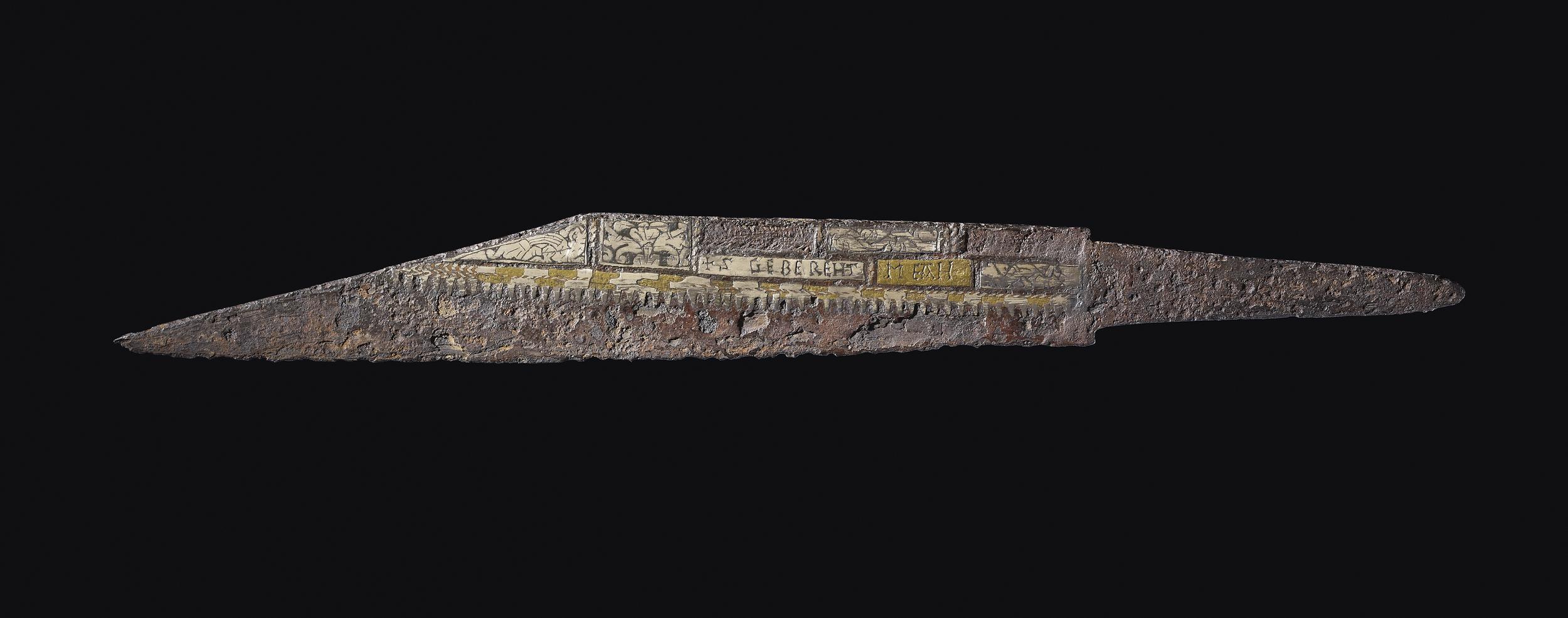
Iron seax, with a straight cutting edge and sharply angled back, the tang offset from the blade.
© The Trustees of the British Museum.

It is from the Saxons that the County of Essex (along with the Ancient County of Middlesex) takes its name. The Boundary of Essex still resembles that of the Saxon Kingdom of Eastseaxe. And it is from this Saxon heritage that Essex adopted the seax as it’s symbol.

The Coat of Arms itself was in regular use well before the grant from the College of Arms in 1932 albeit unofficially. It is likely that the Arms were first assigned to the Saxon Kings of Essex by the more romantic minds of the Late 16th and early 17th Century, as the heraldry in any recognisable sense would not exist until the 12th Century.

One of the earliest mentions of a coat of arms is by Richard Verstegan who writes in 1605 of the East Saxons having two types of weapon, one long and one short. The latter being worn “privately hanging under their long-skirted coats” and “of this kind of hand-seax Erkenwyne King of the East Saxons did bear for his arms, three argent, in a field gules”

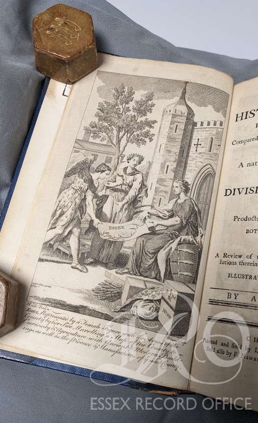
Peter Milman’s History of Essex 1771 (LIB/942.67 MUI1-6)

By the 18th Century the use of the Arms seems commonplace, in 1770, Peter Muilman published the first volume of his History of Essex. The frontispiece shows a shield with the three seaxes although with an unfamiliar shape.

The Plans for the building of the Shire Hall in Chelmsford drawn up in 1788 (Q/AS 1/1) clearly show the Seaxes emblazoned on its neo-classical portico. These wouldn’t form a part of the final design though with this space being blank in an engraving from 1795 (I/Mb 74/1/59) shortly after the building’s completion. It now houses a clock.

[You can find about more about the history of Shire Hall on our blog  – ed]

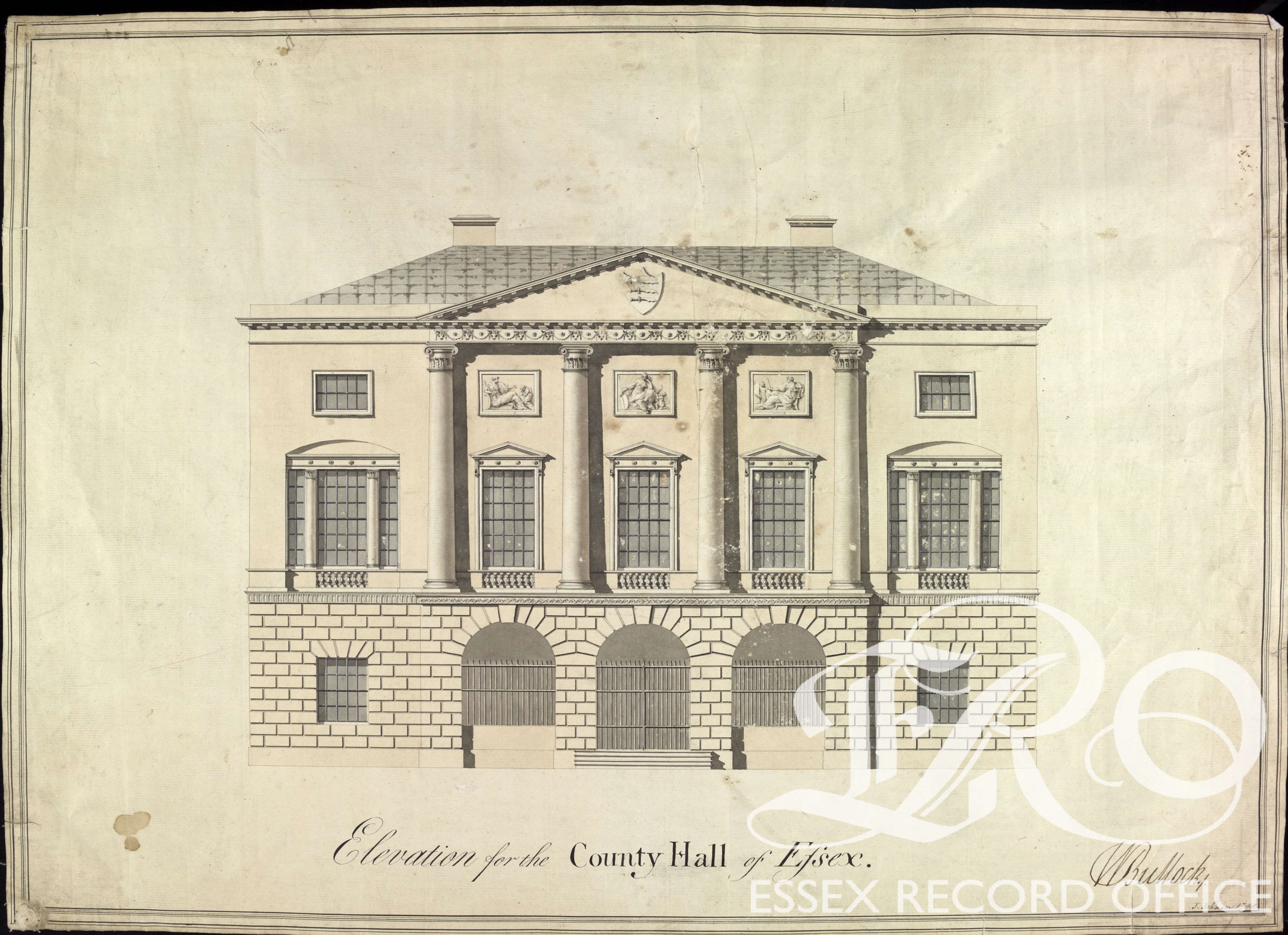
John Johnson plans for Shire Hall 1788 (Q/AS 1/1)

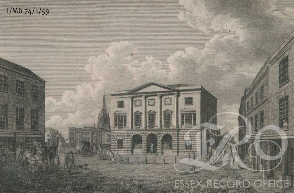
Engraving of Shire Hall shortly after it’s opening 1795 (I/Mb 74/1/59)

The seaxes on a red field would make numerous other appearances, among them: the Essex Equitable Insurance companies fire plate from around 1802; the Essex Local Militia ensign formed in 1809 and the Chelmsford Gazette in 1822. It appears on the cap badge of Essex Police and who remembers the single seax that appeared on the original logo for BBC Essex way back in 1986?

BBC Essex logo from 1986

The shape of the seax on Coats of Arms has led to confusion and myth. As you can see from the examples here, the shape of the Seax changes with use, the notched back of the weapon may simply be to distinguish it from a scimitar for which it is often mistaken. The notch itself has gained a myth all of its own. To many people the notch exists so that the Saxons could hook their Seax over the cap-rail of an enemy longboat to haul it closer.  This sounds rather difficult to achieve, but also to justify, given that the notch doesn’t appear on any of the real world weapons categorised as Seaxes.

The Coat of Arms of Essex

Either way, the Essex Coat of Arms remains an enigmatic and iconic link to our county’s Saxon past.

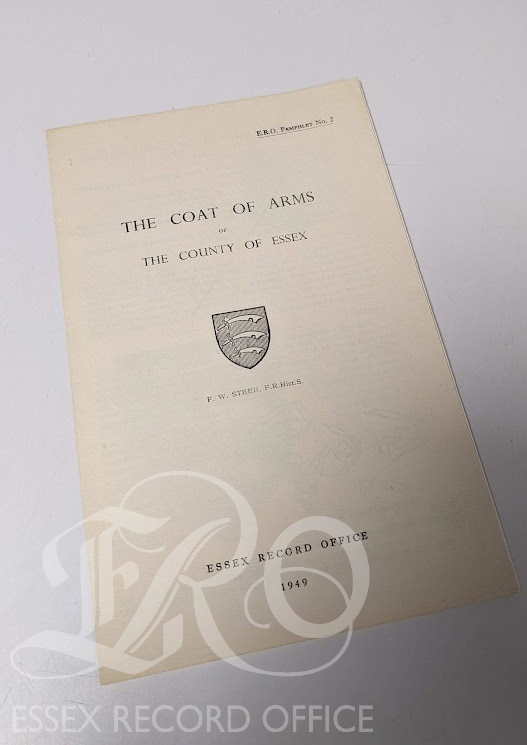
I owe much of the information that I have garnered from the excellent pamphlet ‘The Coat of Arms of The County of Essex’ produced by F.W. Steer, an Archivist at Essex Record Office ,in 1949 (LIB/929.6 STE) which is well worth a read on your next visit.

Communicating Connections

Are you interested in local history? Maybe you know someone who worked for the Marconi Company? Communicating Connections have a unique opportunity for you to get directly involved in the collection of some of Chelmsford’s most well-known history. Find out more about how to get involved in this exciting project as a Volunteer Oral History Interviewer below.

An early mobile broadcasting tower

‘Communicating Connections’ is an oral history-based community heritage project funded by the National Lottery Heritage Fund, with contributions from Essex 2020 and the Friends of Historic Essex. It will explore the heritage of the Marconi Company, one of the most famous telecommunications and engineering companies in the world, based in Chelmsford. We will collect and archive oral history interviews with past employees of the company which will then inform an exhibition and a heritage trail app. Chelmsford is known locally as the ‘birthplace of radio’, so we want to share this heritage with the local and wider community.

We’re looking for 6 volunteer oral history interviewers to conduct 30 interviews in total with veterans of the Marconi Company. Full training in oral history interviewing will be provided by the Oral History Society and further support will be available throughout the project so there’s no need for prior oral history or interviewing experience.

The winding shop

We anticipate that interviewing will begin in November 2020, but please note this may change due to the ongoing Covid-19 pandemic and government guidelines. All activities and interviews will be risk assessed and Covid-19 procedures will be in place.

More information can be found in the volunteer recruitment pack here.

Please direct any questions to the Project Co-ordinator, Laura Owen at communicatingconnections@gmail.com 

The Reach of The Marconi Photographic Section

Lewis Smith, the Essex Record Office’s Engagement Fellow, takes a look at some of the things in the Marconi Photographic Section’s archive.

Founded by Guigielmo Marconi in 1897, the Marconi Company (which held various names over its lifetime) were pioneers in wireless technology. Famously based in Chelmsford (regulars in the area will draw attention to places like ‘Marconi Road’ and ‘Navigation Road’), his technologies helped to shape the world we live in today: so much of our lives are a result of their research, from radio to navigation, from aeronautics to maritime, from communications continent to continent.


A11449 – 16748 MARCONI CO. TRADE MARK OR LOGO, 1947.

One part of the most interesting parts of the Marconi Company’s history was the Marconi Photographic Section, whom took hundreds of pictures over the organisation’s lifetime. These records are now stored at the Essex Record Office in Chelmsford. Unfortunately, this collection remains largely underused – so the British Society for the History of Science and Essex Record Office tasked me to spend some time scoping out the Marconi Photographic Section’s archive, working out what kind of images are within and, perhaps most importantly, work out how they can be used. Whilst I have only been in the archive for a relatively short period of time (since the beginning of October), there are some very interesting historical angles in desperate need of further research – from business to imperial history, from labour to marketing history.


A11449 – 78774, MAP OF NADGE RADAR CHAIN, 1968

One thing to note is that there are a lot of pictures of non-descript machines and circuitry – fans of the history of electronic engineering need look no further: historians of oscilloscopes, transmitters and receivers, power supplies, RADAR arrays, and pretty much all kinds of specialist electronic engineering will find something of interest here. These images present an extensive product history of Marconi’s inventions and patents. Perhaps more generally appealing, there is a lot for those interested in maritime and aeronautical history: one of the key ideas that came about from wireless communication was the idea of wireless navigation, and Marconi fitted many different pieces of equipment to aircraft and ships to aid in their navigation around the globe.


A11449 – 15771, TYPE D.F.G.26 RECEIVER WITH OSCILLOSCOPE TYPE O.R.3, 1945

But the view of higher international politics, engineering and industry are only one side of the coin: the prevalence of this technical equipment masks ordinary life. The archive presents us with a rich social history of the worker and their working practices. Workers, many male and female, black and white, British and international, are presented in the factories assembling intricate circuits. To look at the ethnography behind the people in these pictures reveals the clear shifts, both natural and forcible, in middle and working class employment. Notice particularly with image 2015 – everyone is happy and content, giving the viewer the impression that everything was okay working for Marconi. It wasn’t always this sweet.


A11449 – 2015, GIRLS WINDING & LACQUERING SHOP AT WORKS, 1919

As this is evidently the photographic archive of a business, there is huge scope for a business historian. These photographs are frozen moments in time, specifically captured because they want to show a particular angle, person, product or scene – why one moment and not another? Why one person over another? Why one place over another? More specifically, there are multiple photographs of how the Marconi Company attempted to market itself in a world of innovation: some of the most interesting pictures are of the exhibits set up to advertise wireless communication at various exhibitions.


A11449 – 2464, MARCONI STAND, AERO EXHIBITION, OLYMPIA, 1920

What is most interesting about the archive is the company’s vast spread throughout the globe: as with any history of the twentieth century, Empire remains front and centre. Imperial conquerors can come and go as they please, but radio technology meant the constant connection between colony and coloniser. Furthermore, the concept of technological Imperialism remained hot in this period: teaching others how to use Marconi equipment orients them towards using that equipment for a long time, forcing the colony to ask for technical help from the coloniser. This relationship is observable in the photographic archives as Marconi equipment was placed in different colonies, greatly expanding the imperial nation’s reach.


A11449 – 3070, MAHARAJAH USING A MARCONI TELEPHONE IN INDIA, No date.

Art lovers may also find something worthwhile in the archives. There are photographs of many different artistic drawings by members of staff in the collection depicting a variety of different scenes. The collection features many talented artists, as well as plastic models of Marconi scenes and vehicles, models of scientific principles, and copious drawings. It is easy to fall into the trap of thinking that science and art are two separate unconnected topics, but the collection features some stunning images which clearly appeal to the art behind science.


A11449 – 14559, PAINTING ENTITLED “VOICE OF FREEDOM”, 1943.

This collection is for use in the Essex Record Office under Accession A11449 in over 100 individual boxes. This project hopes to eventually digitise and map these images to show the company’s reach. I have spent time electronically tagging the pictures with keywords: if you would be interested in looking at this spreadsheet or further discussing the project, do contact me at lcsmit@essex.ac.uk. Whether for research or for a casual perusal, this collection really has a lot to offer!

Chelmsford Then and Now: layers of history

In the twelfth and final post from our Chelmsford Then and Now project, student researcher Ashleigh Hudson explains how during her research project we used maps to establish areas of continuity and change in the High Street of our county town.

A key objective of the Chelmsford Then and Now project was to establish what has changed and what has stayed the same over time in the centre of our county town. We are lucky that Chelmsford has been mapped and re-mapped several times over the centuries, enabling us to make comparisons over time, and to find traces of the medieval town in today’s High Street, even though no buildings from that period survive. In this post we will show how we have used maps in this project to look at the detailed history of specific properties.

The earliest known map of Chelmsford was drawn up by John Walker in 1591. The shape of Chelmsford High Street, as depicted on the Walker map, is remarkably similar to the shape of the high street today; in fact the basic make-up of the town has not changed in nearly five hundred years. Internally, the shape and size of individual properties has varied significantly over time, reflecting changing economic, demographic and technological trends. The 20th century in particular saw sweeping changes to areas of the high street. As the town’s population increased, the demand for more retail spaces grew, and the arrival of department stores facilitated the absorption of many of the smaller businesses.

southend saturday

Extract from John Walker’s map of Chelmsford, 1591.

Observing the sites of 61-66 High Street on several Ordnance Survey maps, it was immediately obvious that a number of properties had been consolidated, demolished or rebuilt over time. Using the first edition OS map of 1876 as a starting point, it is clear that large, department sized stores were not yet a standard feature of the high street. Based on this map, we can see that properties in this section of the high street were small and packed closely together, perhaps the result of centuries of uncoordinated and sporadic development.

(2) OS Map 1876

Extract from the 1876 first edition OS map, from the west side of the high street. 61 High Street is occupied by the Queen’s Head inn. Adjacent to the Queen’s Head sits a narrow passageway, which leads from the high street into the yard. To the north of the passageway is the site of 62 High Street and adjacent to that, a number of small, individual properties, all of which would ultimately form part of the Marks and Spencer’s site in the 1970s.

For a more direct comparison, we took photographs of the OS maps from 1963 and 1974 and uploaded them into Photoshop.

(3) 1963

Extract from the OS Maps of 1963 and 1974 showing the sites of 61-66 High Street. The 1963 extract has been highlighted in red, while the 1974 extract has been highlighted in blue.

(4) 1974

Extract from the OS Maps of 1963 and 1974 showing the sites of 61-66 High Street. The 1963 extract has been highlighted in red, while the 1974 extract has been highlighted in blue.

From there we layered the maps, drawing around the border of each property using different colours to make it easy to differentiate between them. Areas where the borders had shifted were then clearly visible, indicating where and when development had occurred.

(5) 1963 and 1974 layered

Extract from the 1963 map highlighted in red, layered with the extract from the 1974 map highlighted in blue.

At first glance, the OS map of 1963 appears remarkably similar to the OS map of 1876. There are still plenty of small properties, packed closely together. The Queen’s Head is still present, identifiable by the ‘PH’ for public house. The property retains its distinctive shape and the narrow passageway, sandwiched between 61 and 62, is still visible.

The biggest and most obvious changes have occurred by the OS map of 1974. The 1974 map presents a significantly changed section of the high street. The former Queen’s Head building has been demolished, and in its place a uniform, rectangular building has been erected. The narrow passageway has been built over and now features as part of the sites of 61 and 62. The sites of 62-66 now form one large property, occupied by Marks and Spencer’s.

(6) SCN 4595

Photograph of the west side of the high street including the Queen’s Head in the centre and several properties to the right that would eventually form part of the Marks and Spencer’s site. Photo by Fred Spalding.

(7) Current Image

A current image of the west side of the high street.

This map comparison perfectly illustrates how the town was transforming in the 20th century to accommodate modern development. In many cases the new buildings replaced small, dated properties which were considered no longer fit for purpose. The imperfect, quirky buildings visible in the Spalding photograph above were replaced by larger modern buildings built over several of the historic plots. Whether these new, spacious retail establishments improved the overall appearance of the high street is open to debate.

If you would like to use historic maps for a project of your own, do come and visit our Searchroom where staff will be happy to help you get started.

And that’s all from the Chelmsford Then and Now project! We will shortly be publishing the results of a similar project undertaken in Colchester so if you like old maps and historic photos there are more treasures to come.

Chelmsford Then and Now Project: Photographs and Photoshop

In our eleventh and penultimate post from our Chelmsford Then and Now project, Ashleigh Hudson explains how during her research project we compared historic photographs of Chelmsford High Street with today’s streetscape.

Chelmsford is often (we think mistakenly!) viewed as having little in the way of historic character. We would argue that there are, in fact, as many examples of continuity as there are of change, and the key is to know where to look. One of the invaluable resources used during this project is the Spalding photographic collection of some 7,000 images. The Spalding family of photographers were based in Chelmsford High Street from the 1860s until the 1940s, and recorded how the street has changed over time.

Fred Spalding senior was a self-taught photographer who set up the family business in Tindal Street in the mid-19th century. His young son, also called Fred, took a keen interest in his father’s business and quickly picked up the family trade. Several years later, an adult Fred relocated the thriving business to the site of 4-5 High Street (the current site of NatWest), where he established himself as the town’s ‘go-to’ photographer. The Spalding family captured Chelmsford through time, and their legacy endures through their magnificent collection of images. You can read more about Fred Spalding and the Spalding shop here.

We have done our best to recreate some of the Spaldings’ classic shots of the High Street, taking a set of prints out with us and dodging showers to do replicate the original pictures as closely as we could.

A quick comparison of some of the images revealed a high level of continuity across the upper half of most of the buildings. While the various owners and occupiers have changed over time, many of the architectural details have endured.

(1) SCN 2261

Photograph of the Spalding shop c.1930

(2) Current Image 4-5

The same building today. Beneath the layers of cream and pale blue paint, the upper exterior of NatWest is very much the same as when the building was occupied by Spalding.

Armed with our fresh images, the fun could really being. Using Photoshop, we layered the old photographs on top of our new ones, blending the two images together:

(3) Photoshop Print Screen 1

The Spalding image is layered over the top of the current image. The image is resized and repositioned to fit the intended space

(4) Photoshop Print Screen 2

It was then possible to blend the Spalding image into the current photograph.

(5) SCN 2-Current

A finished example of this process. The edited image stretches down the high street, from the present day to the past.

In some instances, such as with Jamie’s Trattoria/Barclays Bank (no.2 High Street), the level of continuity is striking.

(6) SCN 1188-Current

Barclays Bank c.1930 layered over the current occupier, Jamie’s Trattoria.

In contrast, areas where entire stretches of the High Street were demolished and rebuilt, such as the sites of Paperchase and M&S (61-62 High Street), the edited images revealed how parts of the High Street are completely unrecognisable.

(7) SCN 4595-Current

The west side of the high street featuring the Queen’s Head in the centre and a building that would later form part of the future site of Marks and Spencer’s. These buildings have since been demolished and the site redeveloped, which is why the images do not match up smoothly.Ch

You can see the final results of our image blending on our Historypin page, or you can visit the Searchroom to explore the full extent of the Spalding photographic collection.

Chelmsford Then and Now: 62 High Street – from prison to M&S

In this tenth blog post in our Chelmsford Then and Now series, our former student researcher Ashleigh Hudson looks at her final property. Today the site is part of Marks and Spencer’s – but in times gone by it was used for a rather different purpose…

From the early 17th century, a large portion of the current site of Marks and Spencer was occupied by the county’s House of Correction. By the early 19th century, deteriorating conditions forced the closure of the House. The site was eventually demolished to make way for several new buildings. The site housed various retail establishments until the 1970s when sites 62-66 were absorbed by Marks and Spencer.

Houses of Correction were established in the early 17th century, as a place to send vagrants, beggars, and those ‘unwilling to work’. Petty criminals and prostitutes could also find themselves committed to these institutions. The inmates were put to work, but were often not there for very long. A spell in a house of correction may well also have included whipping, especially for those charged with offences such as theft or prostitution.

From 1587 the county House of Correction was situated in Coggeshall, but by 1593 the property had deteriorated considerably. The house was sold in 1611 and the county purchased the site of 63-64 Chelmsford High Street. Shortly after, the House of Correction admitted its first prisoners under the watchful guard of Keeper Walter Kellaway.

In order to provide suitable work for the prisoners, Kellaway was in charge of a range of equipment including mills to grind wheat and malt, wheels to spin flax and cotton, and billets for pounding hemp. Perhaps anticipating being charged with unruly or troublesome individuals, Kellaway also had chains and manacles. This account list highlights the interesting contrast, inherent in all houses of correction, between punishment and reform.

q-sr-197-143-watermarked

Bill of implements for use in the House of Correction, 1612, including ‘A mill to grind wheat’, ‘2 Wheels to spin flax’, ‘7 Paid of cards to card wool’ (Q/SR 197/143)

Prisoners from across Essex were admitted to the house on a range of charges, as punishment for perceived lewd, idle, vagrant or disorderly behaviours. Peter Lake was admitted in 1616 for vagrancy and ‘keeping the company with the wife of John Mayfield as if she were his own wife’, while Susan Larkin was admitted in 1617 for ‘living lewdly and out of all order to the disquiet of her neighbours’.

Women accused of being pregnant out of wedlock were often admitted to the House for a whole year. A Bastardy Order made by Sir Henry Mildemay and Sir John Tirell condemned Elizabeth Clarke to the House of Correction to receive ‘due punishment’. The Justices, apparently on the complaint of the town, ordered the reputed father to pay 12d weekly until the child was able to provide for itself. (There is no mention as to whether he was also sent to the House of Correction, but we can probably safely assume he was not.)

q-sr-294-22

Bastardy Order made by Sir Henry Mildemay and Sir John Tirell committing Elizabeth Clarke to the House of Correction, 1636. (Q/SR 294/22)

Prisoner escapes were not a common occurrence, although it was a cause of concern given the location of the House of Correction in the High Street. In April 1776 the Chelmsford Chronicle reported that prisoners had escaped from their ground floor dormitory at the House of Correction in the early hours of one morning. In scenes reminiscent of the Shawshank Redemption, prisoners reportedly pulled up the floorboards with a gimlet and tunnelled under the foundations into the yard. Despite the best efforts of the local constabulary, several of the prisoners remained at large three days later.

chelmsford-chronicle-5-4-76-watermarked

Article from the Chelmsford Chronicle reporting the escape of 15 prisoners from the House of Correction, 5 April 1776

In the mid-18th century the House of Correction expanded to include three brick prison buildings where the more unruly prisoners were detained. The original timber-building, fronting the High Street, continued to be used by the Keeper and his family. Renowned prison reformer John Howard described his visit to the House of Correction in his 1777 book entitled The State of the Prisons in England and Wales. The men and women had separate quarters, with the men’s accommodation located on the ground floor and the women’s, to the same design, located on the floor above.  The Keeper, Thomas Ford, informed Howard that prisoners had an allowance of three-pence a day, for which they had a pound and a half of bread, and a quart of small beer. Howard described the courtyard as ‘small and not secure’ resulting in the prisoners always being kept indoors. Furthermore, he described the rooms as ‘offensive’ and generally inadequate.

Several years later, reformer James Neild visited the House of Correction and met with the Keeper Thomas Ford who he found to behave ‘…not only very humanely, but also very religiously to his prisoners’. While Neild found the house to be under satisfactory leadership, the same could be not for the state of the property, which Neild concluded had:

…many and great inconveniences, and is by no means calculated for the purposes to which it is applied.

By 1803 the premises had deteriorated further and on a subsequent visit, Neild was compelled to report this damning verdict:

On my visit the 31st July 1803, I found the good old keeper dead; the whole prison [was] filthy and out of repair; in the two upper rooms five women and two children sick on the floor; the straw worn to dust; and in one of the rooms a cartload of rubbish heaped up in a corner. In one of the sick rooms below were four women; in the other room six women and two children, one of the women quite naked, another without a shift, the other four had neither shoe nor stocking…The whole prisoners were coniferous, and almost desperate for water…The prisoners complained of the want of medical attendance, and, if I may judge from the filthiness of the fores and bandages, not without reason.

Not surprisingly, Neild was relieved to discover that a new site had recently been purchased adjacent to the new county gaol. The site was completed in 1806, with the prisoners moving in that same year.

(2) SCN 1037

Illustration depicting the new site of the House of Correction and County Gaol.

Suggestions as to what to do with the vacant site continued for some time. At one point it was hoped that the site should be redeveloped to accommodate the judges visiting the town for the Assizes although this plan never came to fruition. The property was ultimately sold in 1811 and demolished a year later, making way for two new brick houses.

Various retail properties occupied the site over the course of the 19th and 20th century, including a branch of Singer’s Sewing Company (at no. 64). In the 1970s, the individual sites of 62-66 were consolidated by Marks and Spencer, forming one of the largest stores on the high street.

OS maps of Chelmsford 1963 and 1974

OS maps showing dramatic change on the west side of Chelmsford High Street between 1963 and 1974. The largest store seen on the 1974 map is Marks and Spencer

The extract from the 1963 OS map above depicts 62-66 prior to the arrival of Marks and Spencer. There are a number of small properties, packed closely together, dominating the stretch currently occupied by M&S. By 1974, these properties had been consolidated to form one large property. The 1974 OS map presents a significantly cleaned up version of the high street. Marks and Spencer continue to occupy the same spot on the high street today.

If you would like to find out more about the House of Correction or any other of the topics covered in this series, Hilda Grieve’s excellent two-volume history of Chelmsford, The Sleepers and the Shadows, is available in the ERO Searchroom, or you can dive straight in to Essex Archives Online and explore our catalogue. For a contemporary account on the state of prisons in the 18th century see John Howard’s, The State of the Prisons in England and Wales.

______________________________________________________________________

Discover more of Chelmsford’s history at:

Chelmsford Through Time

Our county town of Chelmsford may look modern on the surface, but look a little deeper and you will find layer upon layer of history waiting to be discovered. Chelmsford’s history is richly told by maps, photographs and sound and video recordings, as well as documents. Come along to see and hear them for yourself, and for a talk from architectural historian Dr James Bettley on some of the major changes to the town since the Second World War.

Saturday 29 October, 10.30am-3.00pm (talk at 1.30pm)

Essex Record Office, Wharf Road, Chelmsford, CM2 6YT

No need to book, suggested £2 donation (places at talk first-come-first-served)

Chelmsford Then and Now: 26 High Street – Royal Bank of Scotland

In the ninth post in our series looking at the history of Chelmsford High Street, Ashleigh Hudson looks at no. 26 High Street through the centuries. Find out more about the project here.

Over the centuries, the lives of a whole cast of characters have played out at no. 26 Chelmsford High Street. Its origins are as a private residence, but it was used during the 19th century as grand lodgings for travelling judges visiting the town. Later it accommodated the Essex Weekly News offices, and today is occupied by the Royal Bank of Scotland.

In the early 18th century the property was owned by the Goodwin family of goldsmiths. They sold it in 1718 to Sherman Wall, an apothecary, who later passed it to his son, also apothecary named Sherman. In about 1738 Sherman’s daughter Amey married Benjamin Pugh, who was himself a child of an apothecary. Benjamin was a surgeon, and a pioneer in the fields of midwifery and smallpox inoculation. As part of their marriage settlement it was agreed that Amy would inherit the site of 26 High Street upon her father’s death. The building on the property must have been substantial, as it is referred to as the ‘mansion house’.

The marriage settlement of Benjamin Pugh and Amy Walls in which 26 High Street is referred to as the ‘mansion house’. (D/DU 755/45)

The marriage settlement of Benjamin Pugh and Amy Evans (nee Wall) in which 26 High Street is referred to as the ‘mansion house’, 1738 (D/DU 755/45)

Sherman Wall died in 1744, and by 1755 Benjamin Pugh established full control of the property and had commissioned the demolition of the existing buildings to make way for the handsome red brick four storey town house we see today. Benjamin owned the property until 1772 when he sold it to John Lucy.

For several decades in the 19th century the house was used to accommodate judges who were visiting Chelmsford to preside at the Assizes – periodic courts which heard the most serious criminal and civil cases. The engraving below, by J. Ryland, depicts the grandeur of the Assize procession through the High Street.

Engraving by J. Ryland depicting the judges’ procession through the High Street prior to the opening of the Assizes. (I/Mb 74/1/109).

Engraving by J. Ryland depicting the judges’ procession through the High Street prior to the opening of the Assizes. (I/Mb 74/1/109).

These lodgings must have been rather more luxurious than the judges had endured in the past. In 1806, the High Sheriff of Essex, James Urmston, wrote to the chairman of the Quarter Sessions (the county authority which preceded the County Council) highlighting the inadequacy of existing lodgings for the visiting judges. Accommodation had been provided by the Ipswich Arms (site of 73 High Street) which, according to Urmston, was in such a dire state the building faced demolition. Certainly, Urmston thought, the accommodation was not befitting ‘men distinguished by their rank and talents and venerable years of learning’.

The judges requested that their new lodgings should contain two dining or sitting rooms for the judges themselves, a sitting room for attendants, an office for the judges’ officers and clerks, a servants’ hall and large kitchen as well as eleven separate bedrooms.

After spending a few years in temporary lodgings in various private residences, a solution to the judges’ woes was found in the shape of the mansion house. The property had been purchased in 1811 by James Potter, a draper who had intended to use the house as his main residence. Shortly after purchasing it, however, Potter agreed to its use as judges’ lodgings. The judges must have been comfortable there as the arrangement continued until the house was sold in 1849.

Extract from the Sales Catalogue of 1849. The property contains a handsome bold staircase which led to a large suite of rooms on the first floor. The document also mentions that the apartments were recently occupied by the Judges of the Assize. (D/DU 755/45).

Extract from the Sales Catalogue of 1849. The property contains a handsome bold staircase which led to a large suite of rooms on the first floor. The document also mentions that the apartments were recently occupied by the Judges of the Assize. (D/DU 755/45).

In 1869 the property was bought by John Taylor and Edward Robbins, who ran the Essex Weekly News. Various alterations were made to the interiors of the building, including the addition of a machine room in 1903. Images captured by Chelmsford’s preeminent photographer Fred Spalding, who lived just a few doors away, show us what the printing room looked like at this time.

Watercolour by A.B. Bamford of 26 High Street in 1906. Occupied by Essex Weekly News. (I/Ba 14/22)

Watercolour by A.B. Bamford of 26 High Street in 1906. Occupied by Essex Weekly News. (I/Ba 14/22)

Building plan of the machine room, 26 High Street. (D/B 7 Pb74)

Building plan of the machine room, 26 High Street. (D/B 7 Pb74)

The Essex Record Office fortunately possess several Spalding photographs which capture the machine room in action.

SCN 1255

Essex Weekly News, Chelmsford High Street (SCN 1255)

Essex Weekly News, Chelmsford High Street (SCN 1256)

Essex Weekly News, Chelmsford High Street (SCN 1256)

Essex Weekly News, Chelmsford High Street (SCN 1257)

Essex Weekly News, Chelmsford High Street (SCN 1257)


(9) Current Image

The 18th century building is currently occupied by the Royal Bank of Scotland.

The Grade II listed building retains much of the original 18th century detailing today, despite having functioned in various capacities since it was built. The site is currently occupied by the Royal Bank of Scotland.

If you would like to find out more about this property see Hilda Grieve’s detailed history of Chelmsford, available in the ERO Searchroom. Alternatively, search document reference D/DU 755/45 on Seax for a large bundle of deeds relating to 26 High Street.

Chelmsford Then and Now: 61 High Street – from pubs to Paperchase

Today, no. 61 Chelmsford High Street is occupied by Paperchase. In the eighth post in our series looking at the history of Chelmsford High Street, Ashleigh Hudson looks at what else has stood on the site through the centuries. Find out more about the Chelmsford Then and Now project here.

In the 16th century, the site of 61 High Street formed part of two tenements known as Cocksayes and Patchings. By 1618, the site was divided into three distinct properties. The central property (61) was occupied by the Ship Inn, later known as the Waggon and Horse. The inn was ideally situated opposite Springfield road, in the heart of the High Street.

Extract from John Walker’s map of Chelmsford, revealing two tenements on part of the site that would later comprise of 61 High Street. (D/DM P1)

Extract from John Walker’s map of Chelmsford, revealing two tenements on part of the site that would later comprise of 61 High Street. (D/DM P1)

From 1798 the inn was known as the Queen’s Head which was described as a ‘good accustomed public house now in full trade’ in 1807. The Sales Particulars reveal a large property, with considerable facilities for entertaining including a bar, a large parlour and a market room.

One of Spalding’s earliest photographs of the High Street c.1869. The Queen’s Head can be seen on the left.

One of Spalding’s earliest photographs of the High Street c.1869. The Queen’s Head can be seen on the left.

The Queen’s Head continued to provide visitors with modest accommodation throughout the 18th and 19th century and the inn benefited from a steady flow of trade.

The Queen's Head can be spotted on the far left of this image (I/Mb 74/1/55)

The Queen’s Head can be spotted on the far left of this image (I/Mb 74/1/55)

A later view of the Queen's Head

A later view of the Queen’s Head

Watercolour of the Queen’s Head Yard by A.B. Bamford in 1906.

Watercolour of the Queen’s Head Yard by A.B. Bamford in 1906.

The watercolour above, by A.B Bamford, depicts the Queen’s Head Yard in 1906. The romanticised image of the yard is perhaps at odds with reality. Most inn yards were a hub of activity, with horses passing through at all hours of the day and night. The yard certainly would not have appeared so inviting a century earlier. In the 18th century the Queen’s Head yard adjoined the prison yard belonging to the House of Correction which occupied the site of 63-64 High Street. Prison reformer James Neild visited the House of Correction in 1803 and reported the building to be ‘filthy and out of repair’ concluding:

‘What renders this wretched prison more unbearable [is] the offensiveness of the hog-stye of an adjoining public house.’

Neild was unfortunately referring to the Queen’s Head. One can imagine the visitors staying at the Queen’s Head did not enjoy a room with a view, thanks to the ‘hog-stye’ and prison yard located to the rear of the property.

By the 20th century, inns and public houses were slowly disappearing from the high street as the demand for retail increased. The Queen’s Head managed to survive until the 1970s when it was demolished. A quick comparison of the Ordance Survey (OS) map of 1963 and the OS map of 1974 reveals that a substantial section of the west side of the high street was completely redeveloped.

The Queen’s Head is identifiable on the 1963 map by the ‘PH’ initials, which stands for public house. The property has quite a distinctive, backwards ‘L’ shape and a narrow passageway is visible, sandwiched between the Queen’s Head and the site of 62 High Street.

The OS map from 1974 reveals a very different property on the site of 61 High Street. The shape of the building has completely changed and the narrow passageway has been consolidated to form part of the new building. Entry to the yard can only be obtained via the rear of the property.

OS maps of Chelmsford 1963 and 1974

OS maps showing dramatic change on the west side of Chelmsford High Street between 1963 and 1974

These maps illustrate how the town was transforming in the 20th century; based on these maps, one would imagine that the west side of the high street is virtually unrecognisable to those who remember the high street as it looked in the 1960s.

(7) Current Image

Current image of Paperchase, occupying the former site of the Queen’s Head.

Today nothing remains of the original Queen’s Head building and the site of 61 High Street is currently occupied by Paperchase.

If you would like to find out more about the Queen’s Head see Hilda Grieve’s detailed history of Chelmsford The Sleepers and The Shadows.  Alternatively, try searching the Queen’s Head in Essex Archives Online. The Essex Record Office possess a fantastic range of OS maps which are available for viewing in the Searchroom.

Chelmsford Then and Now: 58 High Street – jewellers, musicians and vets

In the seventh post in our series looking at the history of Chelmsford High Street, Ashleigh Hudson looks at no. 58 High Street through the centuries. Find out more about the project here.

No. 58 Chelmsford High Street is today occupied by the jewellers, Goldsmiths. John Walker’s 1591 map of Chelmsford identifies a small property named Felsteds on this site. The shop took its name from Henry of Felsted and his son Robert, who purchased the shop in the early 14th century. By the time Walker made his survey the shop was owned by Thomas Hawes.

Goldsmith's jewellers, Chelmsford High Street

Goldsmith’s jewellers, Chelmsford High Street

Extract from John Walker's 1591 map of Chelmsford pointing out the site of no.58 High Street (D/DM P1)

Extract from John Walker’s 1591 map of Chelmsford pointing out the site of no.58 High Street (D/DM P1)

Felsteds was one of the smallest properties fronting the west side of the high street and was recorded as having only 2 hearths in the 17th century. By 1708 the property was occupied by a musician, James Wright. Wright’s will bequeathed a range of musical instruments, bows and strings to his granddaughters, Ann and Lettice Wyatt.

Extract from the will of James Wright, 1708, bequeathing his musical instruments to his granddaughters (D/ABW 79/191)

Extract from the will of James Wright, 1708, bequeathing his musical instruments to his granddaughters (D/ABW 79/191)

Wills are a fantastic source of information which can tell us a great deal about the person who wrote it, particularly in terms of family relations. Wills give a good indication of an individual’s personal wealth, but they can also reveal the items and possessions individuals valued. One would imagine that as a musician, James Wright would have highly valued his collection of instruments.

Wills also provide evidence of property ownership. From 1841 the property was occupied by veterinary surgeon Samuel Baker and his family and we know from Baker’s will that after his death the property passed to his wife, Caroline Baker. The property stayed in the Baker family into the 20th century.

(3) D-ABW 142-1-85

The will of veterinary surgeon, Samuel Baker, 1857.

Throughout most of the 20th century, the site housed various jewellers. From 1922, the jeweller Oram and Sons occupied the site and continued to do so until the 1940s when the store came under the ownership of W.G Webber. This continuity has continued to the present day, with the jewellery chain Goldsmiths occupying the site today.

If you would like to find out more about this property, see Hilda Grieves’ detailed history of Chelmsford, The Sleepers and The Shadows. The Essex Record Office has a fantastic collection of wills, many of which have been digitised and can be accessed through Essex Archives Online.

Information compiled from the research and report produced by ERO Archive Assistant, Sarah Ensor.

Chelmsford Then and Now: 40-41 High Street

In the sixth post in our series looking at the history of Chelmsford High Street, Ashleigh Hudson looks at no. 38 High Street through the centuries. Find out more about the project here.

In the 16th century the site of 40-41 High Street was occupied by a medieval inn called the Boar’s Head. From 1633 the inn was known as the King’s Head and it continued to operate on the site until 1929 when the property was demolished to make way for a branch of F.W Woolworth. Woolworths vacated the site in 2010, making way for the arrival of Barclays Bank, who continue to occupy the site today.

Extract from John Walker's map of 1591 showing the Boar's Head

Extract from John Walker’s map of 1591 showing the Boar’s Head

From the mid-15th century the site of 40-41 High Street contained a medieval inn known as the ‘Boreshed’, which in 1591 was occupied by the widow Anne Bridges. In 1633 the ‘Boar’s Head’ changed its name to the ‘King’s Head’, although the nature of the premises remained the same. The inn benefitted from a prime position on the high street and was a very popular establishment. A Sale Catalogue from 1807 described the King’s Head as an ‘old and well-accustomed inn’. The property boasted a bar, two parlours and a large market room, indicating the inn had the facilities to accommodate a range of events and activities.

(2) SCN 4768

Front view of the King’s Head, Chelmsford High Street (SCN 4768)

The inn was modest in size, but well equipped to cater to the various visitors passing through the town. The inn provided stabling for up to thirty horses, which was accessed through a narrow passageway leading from the high street to the yard. This coloured plan of the King’s Head from 1842 reveals the structure of the property fits the standard pattern for coaching inns.

(3) D-DOP T2

Plan of the King’s Head, Chelmsford High Street (D/DOP T2).

By the early 20th century, a growing demand for retail establishments in the high street led to the closure of many of the town’s inns. The highly respected Walter J. Greenwood, who served as landlord of the King’s Head for over thirty years, was also its last before the inn was demolished to make way for a branch of F.W. Woolworth.

In the 1920s, rumours circulated that developers intended to demolish the King’s Head to make way for an ‘entirely new and handsome premises’. It was hoped that the new building would improve the overall appearance of the high street and bring it in line with other developments.

(4) SCN 3773

Springfield corner several years later. F.W Woolworths has now replaced the King’s Head

The much anticipated Woolworths store opened in the summer of 1929 and was immediately embraced by Chelmsford residents. The fancy new premises included a large shop floor where a wide range of merchandise was displayed. Above the shop floor there was a large store room and several offices for employees. The store initially employed around forty young shop assistants, all of whom were from the Chelmsford area. The shop front contained two entrance swing doors and several large display windows where stock was displayed to entice passers-by. Above the display windows, gold embossed lettering proudly spelled out ‘F.W. Woolworth & Co. Ltd’.

(5) SCN 1514

Woolworths, Chelmsford High Street. Customers frequently left their bicycles, unchained, outside while they popped inside the store to browse

Woolworths continued to operate throughout the Second World War, though the store did not escape completely unscathed.  In May 1943 Chelmsford’s industries were targeted by the Luftwaffe and many of the shops on the high street were caught in the cross fire, including the Woolworths store. The store was struck by burning debris and as a result, the wooden counters towards the rear of the store caught alight. Fortunately, several members of staff, who were reputedly paid ‘danger money’ to sleep in the store overnight, were on hand to douse the flames. The charred site allegedly remained roped off and kept on display for the duration of the war.

The store continued to prosper throughout the rest of the 20th century, with development and expansion occurring periodically. By the 1960s, the store had undergone a vast programme of modernisation. The acquisition of a block of six shops in Springfield Road provided additional space for the store to expand. The new extension was said to have increased counter space and the range of goods on sale. It also created superior staff quarters, a cloakroom, lounge and a spacious canteen. The work took around two years to complete, although the store was said to have operated as normal during this time with minimal disruption to customers. Woolworths remained on the site until the early 21st century when, sadly, the firm went out of business.

In 2010 it was announced that Barclays Bank was in talks to relocate from their premises near the Shire Hall to the site of the former Woolworths store. Barclays have enjoyed a long history in the town, having previously occupied the Grade II listed building now containing Jamie’s Trattoria.

(6) SCN 11

Exterior of Barclays Bank which was built in 1905.

The attractive, red brick three storey building was constructed in 1905 after the former owner, six time Mayor Frederick Chancellor, vacated the site. The property retains all of the original 18th century detailing externally, although obviously the internal modelling has altered substantially with time.

Barclay's Bank Chelmsford High Street

Barclays today, situated on the former site of Woolworths and the King’s Head

The current Barclays store, located to the south of the High Street, has a much more contemporary feel. At street level, the Barclays building may look very different to those who remember its former life as a Woolworths. The upper façade of the building however is very much unchanged and serves as a subtle reminder of a not so distant past.

If you would like to find out more about the site of 40-41 High Street, try searching the Boar’s Head or the King’s Head in Seax. Alternatively, see Hilda Grieves’ detailed history of Chelmsford The Sleepers and The Shadows which is available in the ERO Searchroom. Additional information regarding the Chelmsford Branch of Woolworth’s provided by Paul Seaton of woolworthsmuseum.co.uk