Document of the Month, May 2015: 50th anniversary of the five Essex London Boroughs

This month marks the 50th anniversary of the creation of the 5 London Boroughs of Barking & Dagenham, Havering, Redbridge, Newham and Waltham Forest in the metropolitan area of the ancient county of Essex.

To mark this anniversary, we have cheated slightly with Document of the Month and chosen images of those places when they were still part of Essex.

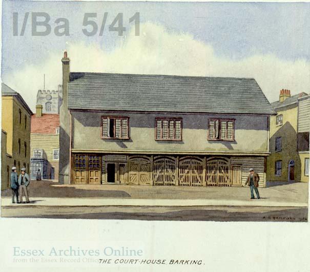
The old Court House or Market Hall or Old Town Hall at Barking was built and paid for by Elizabeth I.  By 1920 it had fallen into disrepair and was demolished in 1923.

IBa 5-41

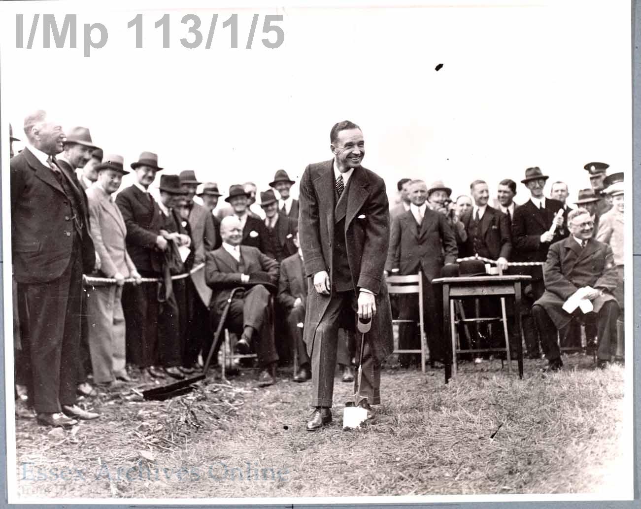
Dagenham will always be associated with Fords.  This photograph shows Edsel Ford cutting the first sod for the factory c. 1929.

I-Mp 113-1-5

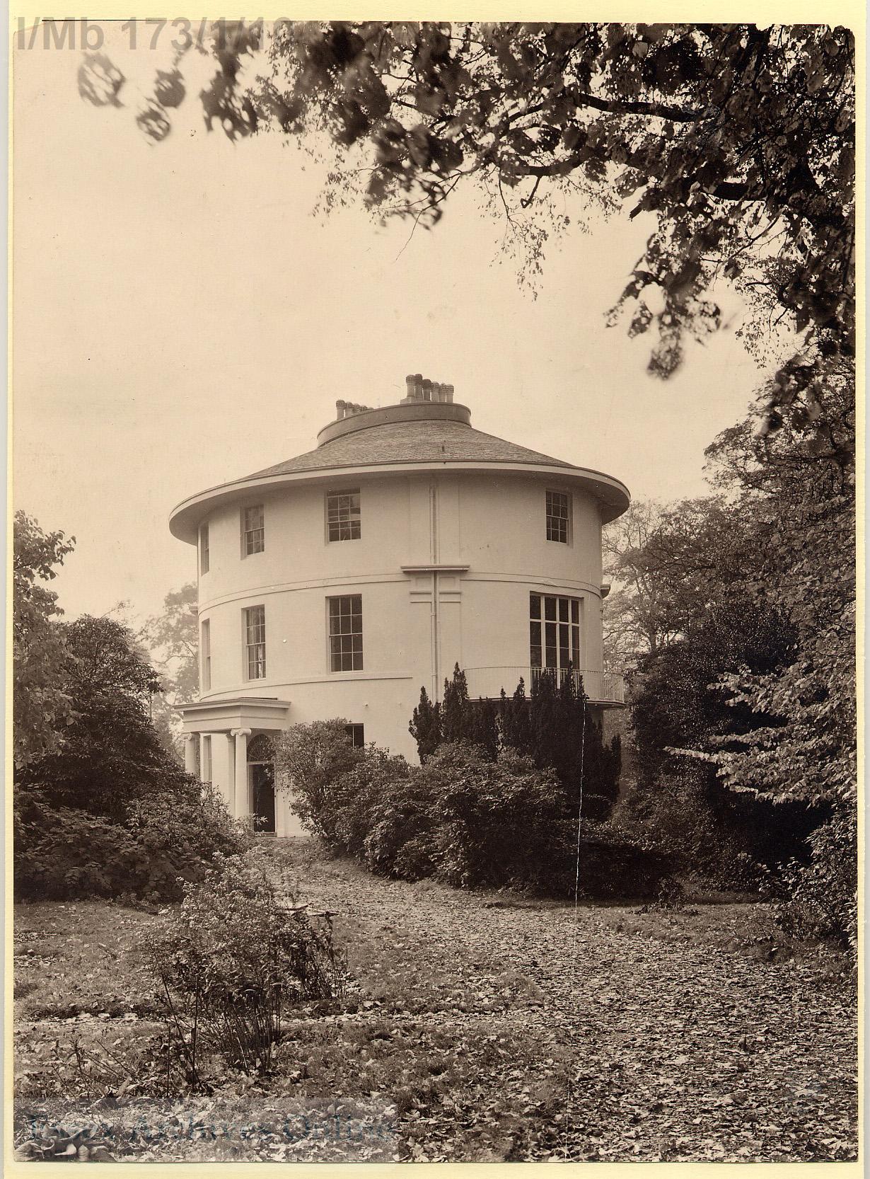
Havering was named for the ancient Royal Liberty of Havering-atte-Bower.  The Round House, Havering was built in 1792 for William Sheldon, a wealthy tea merchant, and was later home to Rev Joseph Pemberton who developed the hybrid musk rose in the 1900s.

I-Mb 173-1-10 watermarked

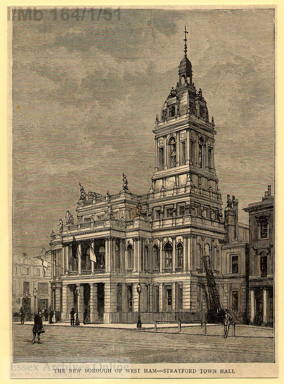
Newham was formed from the County Boroughs of West Ham and East Ham.  This illustration shows the Old Town Hall at Stratford, built in 1869.

I-Mb 164-1-51

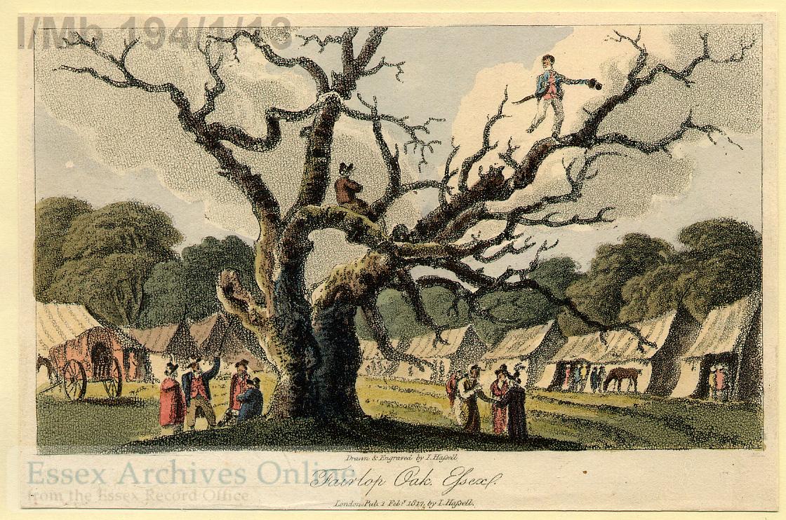
Redbridge was named for a bridge over the River Roding.  Situated in the Borough was the Fairlop Oak, an ancient place for fairs.  Its name continues in the Fairlop Waters Country Park.

I-Mb 194-1-13

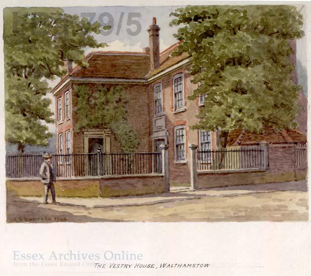
Vestry House, Walthamstow is where the Waltham Forest archives are held.  This watercolour is by A. B. Bamford and dates from 1926.

I-Ba 79-5

Great British Railway Journeys: Ilford to Rochester

With series 5 of Great Railway Journeys continuing tonight on BBC2 episode 18 sees Michael Portillo journeying from the edge of the metropolis in Ilford to Tilbury before crossing the Thames to Gravesend. As with episode 17 we thought we would take a look at some documents related to some of the sights he will be seeing along the way.

The London, Tilbury and Southend railway was granted an act of parliament in 1852 to begin purchasing land; by just 1854 it had reached as far as Tilbury. The railway was intended to link up the growing industries along the north bank of the Thames such as the chalk works at Tilbury and the burgeoning towns of Prittlewell and Southend. Perhaps most importantly for the railway company, the line allowed their customers easy access to the company’s own pier just across the Thames at Gravesend, already a common embarkation point for overseas travel from England.

I/Mb 360/1/28

Riverside Station, Tilbury, 1920

OS 25 inch Sheet 95.12 1920

Ordnance Survey map of Tilbury from 1920 showing the distinctive triangular arrangement of the railway lines, with workers’ cottages in the middle. Click for a larger version.

With the coming of the railway to Tilbury and the increasing prevalence of  steam ships, Tilbury became an attractive location for the East and West India Dock Company to build a new port. It was well positioned downstream and therefore more convenient for ships than docks belonging to their competitors further up-stream in London. Ground was broken in 1882 and the photograph below shows the opening of the docks in 1884 with much fanfare. The port quickly became the most important deep-water port on the Thames and was integrated into the Port of London in 1909.

Opening of Tilbury Docks, 1884

Opening of Tilbury Docks, 1886

Port of London Authority map of Tilbury Docks, early twentieth century

Port of London Authority map of Tilbury Docks, post 1909 after it was taken over by the PLA

Amidst all the clamour of industry and squeezed between a gasworks and the dock itself lies the jewel in Tilbury’s crown. Before industry and the railway Tilbury was important for another reason. Henry VIII had built a simple “D” shaped blockhouse there with an opposite number in Gravesend to defend the Thames with their guns and by drawing a chain across the river between them. With the threat of the Spanish Armada in 1588 the fort was improved and repaired and it was here that Elizabeth I reportedly famously rallied her rag-tag army with the words “I may have the body of a weak and feeble woman but I have the heart and stomach of  a king, and a king of England too”.

I/Mb 360/1/1

Print of Tilbury Fort. There are several views of the Fort in our collections, many of which have been digitised and can be viewed online on our catalogue Seax

I/Mb 360/1/6

Coloured print of Tilbury Fort

Modern European military thinking greatly influenced Charles II during his exile from Britain and led to the redevelopment of Tilbury Fort into its modern star shape in the 1670s. The Fort was held by the Parliamentarians in the Civil War and was refortified in the Napoleonic wars and again in 1914. The Fort straddled the border of the parishes of West Tilbury and Chadwell, with the officers quarters being on the West Tilbury side and the other ranks in Chadwell. This is reflected in the parish burial registers, with officers appearing in the West Tilbury registers, and the men in the Chadwell registers.

D/DU 446 map Tilbury Fort and Gravesend

Extract from map of the Thames around Tilbury and Gravesend, showing Tilbury Fort in 1780. South is at the top of the map, and north at the bottom.

Collections highlight: Southend in historic images

For our second collections post, we thought we would share some highlights from our extensive image collection.

One of our blog’s header images is a picture of Southend-on-Sea, which is probably one of the most photographed places in the county, which given its status as a major Victorian and Edwardian seaside resort is no surprise.

Situated on the mouth of the Thames estuary, Southend first became a resort during the eighteenth century, and tourists have been attracted ever since by its miles of beaches, and later by the longest leisure pier in the world. With its proximity to London and a good rail link, Southend was one of the most popular places for Victorian Londoners to escape to for some sea air. Its popularity declined from the 1960s, however, with the advent of cheap air travel drawing increasing numbers of people abroad for their holidays.

If you would like to find out more about Southend’s past, then you can join our Southend-on-Sea: Stepping Out walk on Friday 18th May, 2.00pm-3.30pm. The walk will trace the history of Southend, from fishing village to Georgian resort to Edwardian London’s playground. The walk costs £5 and advance booking is essential – please telephone 01245 244 620.

I/MB 321/1/32 Black and white print: Marine Parade, Southend J.T. Wood, 278 Strand, London Bound in volume, 'Views of Southend'

I/Mb 321/1/65 Southend from the sea, sailing barge in foreground

I/Mb 321/1/66 View of Pier from the beach, Southend, c.1900

I/Mb 321/1/56 London Tilbury and Southend Railway Poster. Day Excusions to Southend, 1911

I/Mb 321/1/58 Marine Parade, Southend-on-Sea, 1955

I/Mb 321/1/57 Boats at Marine Parade Beach, Southend-on-Sea. Dome of Kursaal in background, c.1955

Our digitisation programme means that many images can now be found on our online catalogue Seax – to search for a digitised image, simply select the ‘Images’ option before you begin your search.

Although many images have been digitised, they still represent a small proportion of our image collections. To search all of our records, simply select ‘Everything’ above the search box. For advice on searching for historic images, you can call us on 01245 244 644.