We are in the midst of preparing for our next ‘on the map’ outreach event, which will take place in the village of Messing near Tiptree on Saturday 19 March 2016. We have done a few of these events in different locations around the county, taking a timeline of maps from our collection out for a special pop-up display.
One of the maps we will be taking with us on this occasion is this 1650 map showing the lands of Messing Hall (D/DH P1).
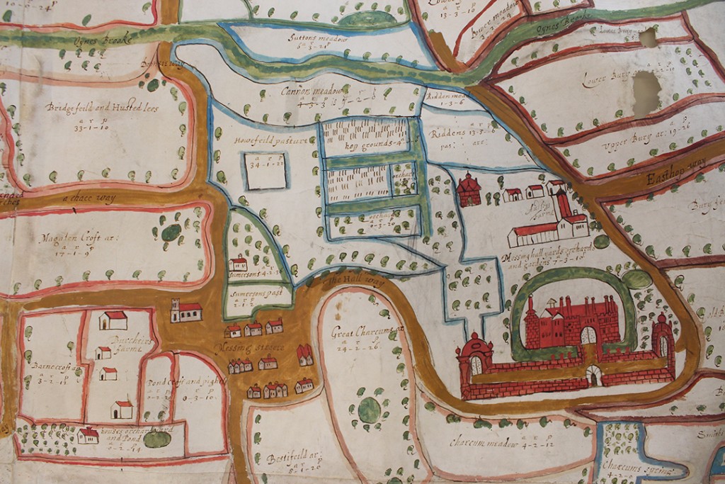
‘A survey of all the lands appertaineing to Messing Hall in the county of Essex with the number of acres the wch was surveyed by William Bacon and Benedict Coule’ (D/DH P1)
Messing Hall itself is shown to the east of the village centre as a very grand moated building, with a farm to the north.
The map is part of a collection of papers relating to the Luckyn family of Messing. Sir Capel Luckyn acquired the estate of Messing Hall in 1650, so presumably he commissioned the map as he took possession of his grand new property.
The map makes an immediate visual impact, but on closer inspection bears only a passing resemblance to the actual layout of Messing – cue ERO staff members scratching their heads and poring over maps, aerial photos and any histories of Messing we could get our hands on, trying to work out what the 1650 map actually showed us.
Trying to work it all out
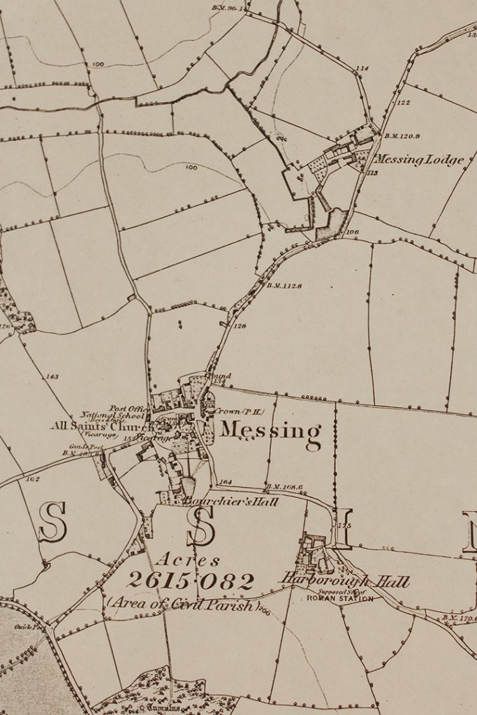
The 6″ : 1 mile Ordnance Survey map of 1874
To begin with it all seemed a confusing mess. While the 1650 map shows the grand Messing Hall on a road heading east out of the village, the Ordnance Survey map of 1874 shows that there is no such road, leaving us with a mystery to solve – where was Messing Hall? The representation of it on the map no doubt blows the size of the house out of all proportion, but clearly an important property existed and we could find no obvious sign of it on any later maps.
There were two main candidates for the site – Harborough Hall, to the south of the village, and Messing Lodge, to the north.
Our sights first landed on Harborough Hall – it was the closest substantial property to the village, and sits on a bend in the road, as does the property on the 1650 map. We read that the manors of Messing and Harboroughs merged in the 1400s, so perhaps the names had been used interchangeably.
Messing Lodge, meanwhile, just seemed too far from the village and too far north. Could the 1650 map really be that inaccurate?
We hunted for anything that would help us tie up the things represented on the 1650 map with more accurate later maps.
Our first breakthrough came from matching up Oynes Brook, shown on the 1650 map, with Domsey Brook shown on later maps. Once we had found the brook, we were able to match up the forked road shown in the 1650 map to the north of Messing Hall with the fork shown in later maps above Messing Lodge. Although not quite the same shape, on both maps one fork crosses the brook (and stops short just after it), and the other fork becomes ‘Easthop way’ or ‘Easthorpe Road’. There are also water features on the 1897 map which could relate to the moat shown in 1650.
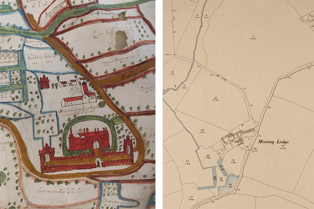
Portion of the 1650 map showing Messing Hall compared with 1897 map showing Messing Lodge
This was pleasing evidence, and was further supported by some of the field names surrounding the property.

Fields named ‘Charcums’ near Messing Hall
The 1650 map shows ‘Great Charcums’, ‘Charcum meadow’ and ‘Charcums spring’ to on the opposite side of the road to Messing Hall. On the tithe map of 1839, fields near to Messing Lodge are known as ‘Little Chalkhams’ and ‘Great Chalkhams’.
With the evidence of the brook, the fork in the road, the road to Easthorpe and the Charcum/Chalkhams field names, we think we have a satisfactory answer to our mystery, and we can put Messing Hall back on the map.
One of the joys of research is problem solving, and the excitement when things finally fall into place, especially when you can share that joy with fellow researchers.
Fortunately for the 1650 map, what lacks in accuracy it makes up for in exuberance. Come along to see it for yourself at Messing about with Maps on Saturday 19 March at Messing Village Hall.
Messing about with Maps
A chance to see historic maps of Messing kept at the Essex Record Office in Chelmsford, including a hand-drawn map from 1650 and the Messing tithe map of 1839.
Saturday 19 March, 10.30am-3.00pm
Messing Village Hall, The Street, Messing, CO5 9TN
Just drop in, suggested donation of £2.00