Changing land usage in Essex

Archive Assistant Neil Wiffen reflects on the changing pattern of land usage and the historic value of meadows to the Essex landscape.

There is currently much in the media about climate change and environmental degradation. We hear on almost a daily basis about the threat to different ecosystems and landscapes, as well as about worldwide species loss. We in the UK are not immune, and subjects such as the loss of meadows and the threat to bees are now quite common topics of discussion. Recently the BBC reported that, ‘over 97% of wildflower meadows have been lost since the 1930s, that’s a startling 7.5 million acres (3 million hectares). Species-rich grassland now only covers a mere 1% of the UK’s land area’ (http://www.bbc.co.uk/earth/story/20150702-why-meadows-are-worth-saving).

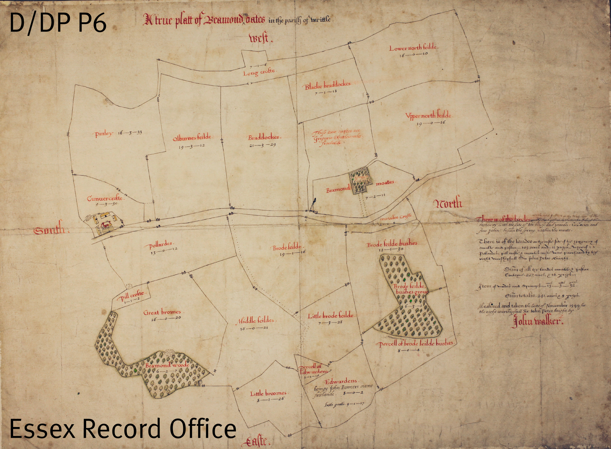
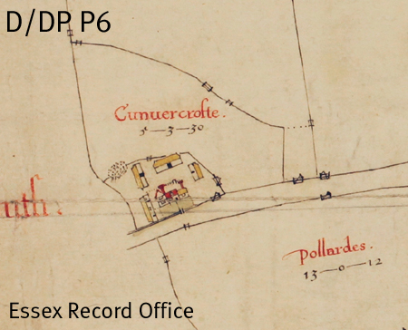
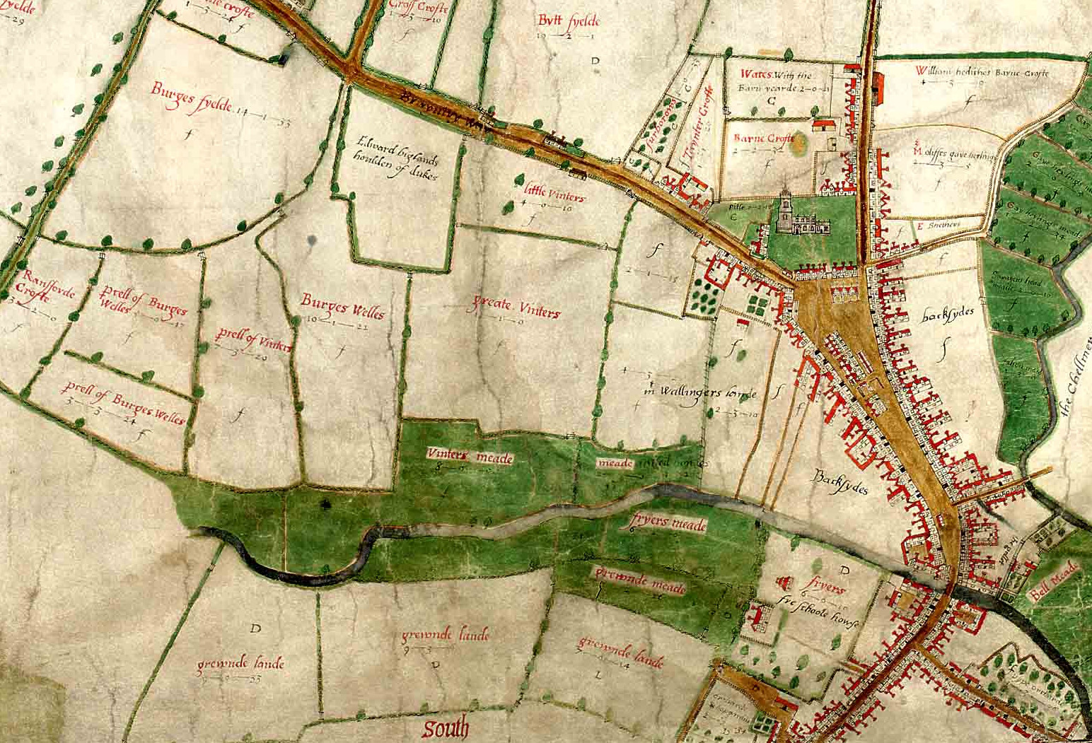
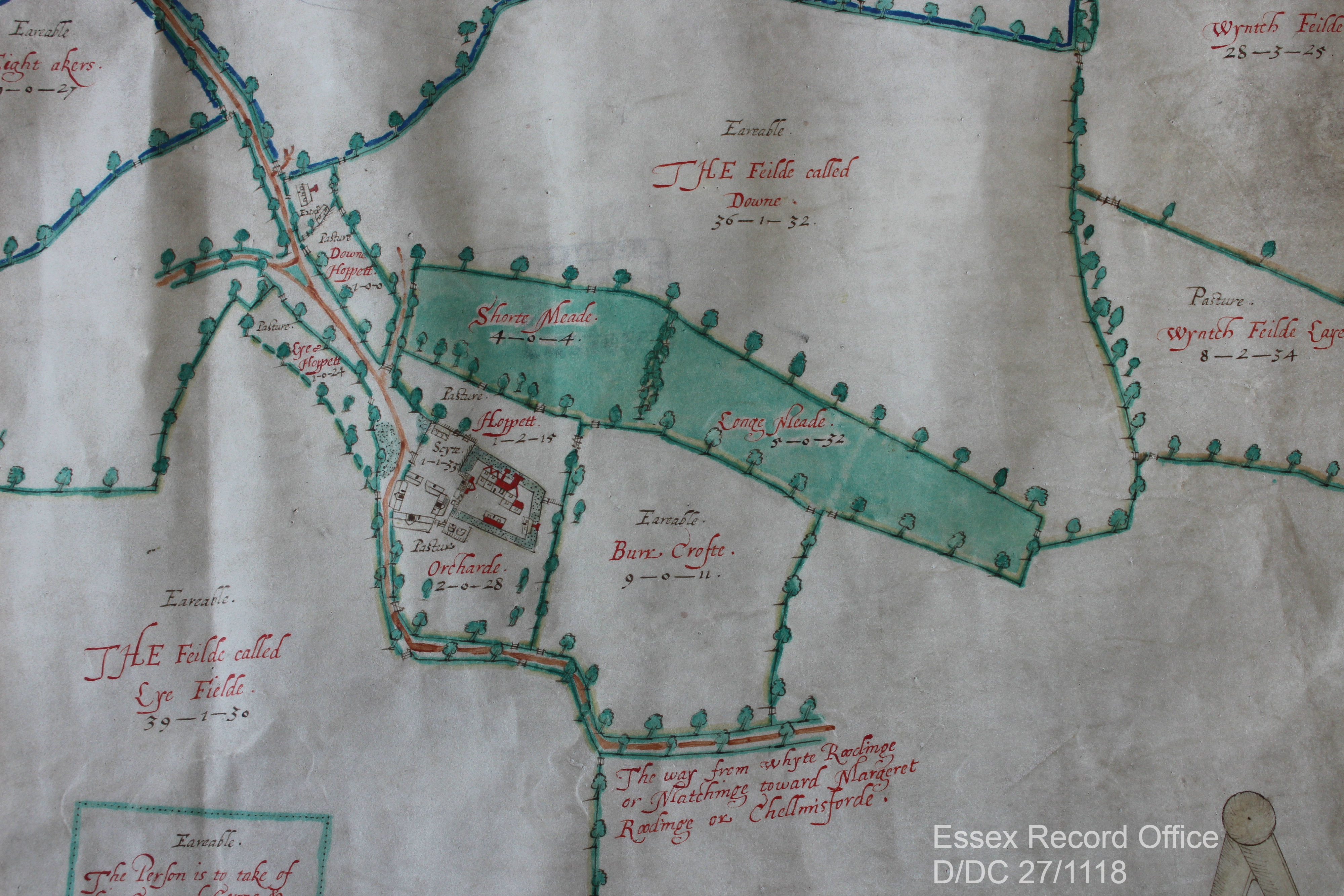
What have bees and meadows got to do with the Essex Record Office (ERO), we hear you ask? Well, working among our wonderful archives we are used to seeing lost landscapes of the past as depicted in maps or described in documents – a land before industrial agriculture and large-scale urbanisation.

One important, almost universal feature of any parish’s landscape would have been that ‘species-rich grassland’ mentioned by the BBC. They were generally described as meadows, which the ERO’s trusty copy of the Oxford English Dictionary (1933) defines as, ‘a piece of land covered with grass that is mown for use as hay. In later use often extended to include any piece of grass land’ (pasture, on the other hand, was used for general grazing of livestock). Look at any tithe, enclosure or estate map and there the meadows will be, often listed and somewhere along the way appraised as well.

Part of 1609 map of White Roding showing meadowland
Extract from John Walker junior’s 1609 ‘trewe and perfect’ plan of the ‘landes belonging to the Mannor of Mascalls Bury … within the parish of White Roodinge’ (D/DC 27/1118). It depicts the ‘Longe’ and ‘Shorte’ meadows adjacent to the moated house. Another important aspect of the farm and household economy, the orchard, can also be seen close by the house. Do note the spelling of arable as ‘Eareable’ – one can almost hear the Essex accent across the centuries!

— An image of the same location from Google Satellite, 2019.

The importance of meadows to people in the past was immense, particularly before the introduction of fodder crops, such as turnips, through the 17th and 18th centuries. Meadows were mown for hay in summer which was then used to feed overwintering livestock. Therefore the amount of hay harvested determined the number of cattle that could be kept over-winter. So a good hay crop was an essential product of the agricultural year, with the whole community coming together to ensure it was harvested and stored successfully.

The high regard that meadows were held in can be seen by how they were valued. When the Escheator compiled the Inquisition Post Mortem (TNA, C 134/74/19) on the death of Nicholas Dengayne in 1322/3, his manors of Colne Engaine and Prested Hall (Feering) were valued. The 240 acres of arable land in the former was valued at 4 pence per acre, while 140 acres in the latter was 3 pence per acre. By comparison the 6 acres of mowing meadow at Colne Engaine and 5 acres at Prested Hall were all valued at 2 shillings per acre –  the equivalent of 24 pence per acre, or six to eight times the value of the arable land.

Quite what types of grasses and flowers these ‘traditional’ meadows were made up of is unknown, but we have to assume in an age before widespread use of agricultural chemicals they were very species rich with lots of insects as well. Not all ‘grassland’ was equal to a well-established meadow. By the 1930s 302,803 acres of ‘permanent grass’ was recorded in Essex (The Land of Britain: the Report of The Land Utilisation Survey of Britain part 82 Essex, copy  in ERO Library, Box 95), of which 92,300 was for hay – possibly this was mainly ancient meadows. The remaining 210,503 acres might not have been of the highest quality but rather a result of the agricultural depressions of pre and post First World War. This would have been the case with the 38,977 acres of ‘rough grazing’ – not all grassland was equal!

A local meadow in glorious technicolour! Along with various grasses there is knapweed, scabious and lady’s bedstraw. The honeyed aroma of the latter is intoxicating on a sunny day!

Now, we are beginning to appreciate our meadows once more and recognise their value as habitats to vital wildlife. While there has been a great loss of meadows, more are being planted, for example by conservation charity Plantlife. Perhaps our maps and documents will guide where new meadows could be sown?

What can you find out about your local landscape history? Check our introduction to the main sources for starting a place history, then come and explore what we have in our Searchroom.

Your Favourite ERO Documents: Map of Chignall by John Walker, 1599

As part of our 75th anniversary celebrations this year, we asked you, our users, to nominate your favourite ERO documents. Today’s nomination comes from Rosemary Hall, and is a map made by John Walker of Chignall in 1599, or to give it its full title, ‘A true platt of Beamond Oates measured and taken the laste of Nouember 1599 for the right worshipful Sir John Petre knight by John Walker’.

The map covers an area of 241 acres about a mile and a half north of Writtle in the modern parish of Chignall. It shows a farm which was part of the estates of the Petre family of Ingatestone Hall, called variously Beamond Oates, Otes, Moates, Motts and Mottes. The map shows the site of a former farm house, labelled as Beamond Moates, and the current house and surrounding barns (see extract below). It measures 17 x 22 inches, and is at a scale of about 26.6 inches to 1 mile. The map seems to have been a draft – it has Walker’s characteristic accuracy, but lacks the finish of some of his other maps, which perhaps suggests that Sir John Petre was happy with the draft as a practical record of the farm.

We’ve written a little already about John Walker and his map of Chelmsford (here); Walker was an incredibly skilled map maker, and his son, also John, took up the profession. A.C. Edwards and K.C. Newton in The Walkers of Hanningfield (well worth a read – available in the ERO library), suggest that this map is the first work we have of John Walker junior – the use of a yellow to represent thatch on the farmhouse is seen in his later maps, and is distinct from the brown his father usually used, and the handwriting of both father and son appears on the map.

D/DP P6 map of Chignall

Walker map of Chignall, 1599, D/DP P6


D/DP P6 map of Chignall

The farm house and barns

Rosemary Hall writes:

[My favourite ERO document] is a Map of Chignal D/DP P6, “A true platt of Beaumond Otes…[drawn] for Sir John Petre.” I grew up in Chignal Road, and walked over that area, and well remember my fascination and delight upon discovering that many of the woods that I knew dated back 400 years! It was one of the things that triggered my interest in local history; along with the encouragement of the Essex Record Office. Alas! I am an exile from Essex now, but I am continuing to research the history of my adopted city of Coventry.

Thank you to Rosemary for turning the spotlight onto this wonderful piece from our collections. If you would like to nominate your own favourite ERO document, we would love to hear from you. Simply download this form, and return it to the Searchroom desk or by e-mail to hannahjane.salisbury[at]essex.gov.uk. There are also paper copies available at the Searchroom desk.

Favourite ERO documents: Walker map of Chelmsford, 1591

As well as asking our users about their favourite documents from our collections, we have also been asking ourselves. Here Public Service Team Manager Neil Wiffen tells us about his favourite document, John Walker’s 1591 map of Chelmsford.

 My favourite document at the ERO has to be one of the best known and most widely reproduced – the 1591 Walker map of Chelmsford. This might be an obvious choice (and could it be said boring?) but for me it works on so many levels.

Extract from the Walker map of Chelmsford, 1591 (D/DM P1)

Extract from the Walker map of Chelmsford, 1591 (D/DM P1)

First of all it is a map and I think everyone likes a map because we can all get something from a map so very easily. We don’t need to read Latin or funnily written handwriting to be able to enjoy an historic map. As maps go it is a sumptuous and artistic map. The colours are still so very vivid even after 422 years and the wonderful portrayal of the buildings by John Walker is exquisite.

Being Chelmsford born and bred it works for me on a local level, a source of civic pride. I can’t help when I walk down the High Street but try and imagine what it would have been like when Walker surveyed the town. Indeed walking down the High Street is to walk in our predecessors footsteps so little has the basic layout of the town changed over the centuries. In a way the map is the nearest we can ever get to late Tudor Chelmsford, so it allows us to travel in time. It is a map that continues to keep me thinking about town development. If ever you’ve been shopping on a Friday or Saturday when they have the market stalls in the High Street you can just imagine what it was like when the Middle Row was developed over centuries. Stall holders didn’t bother to take down their stalls overnight but slept under the counter or added another level and before you knew there was a row of permanent shops which Walker depicts.

It can also be a dangerous map as well. Looking at the layout of Chelmsford in 1591 we can be lulled in to thinking how much nicer it would be to live in a small Chelmsford. Urban development and awful planning decisions of the 1950s-70s have deprived the town of much interest which is there in the Walker map. However, we must not forget the appalling inequality, insanitary conditions and harsh punishments of those earlier centuries.

Last of all it is a map of wonder. How did John Walker survey the town and produce the map? Whenever I look at the map I always think – ‘John Walker, what a clever bloke!’

If you would like to nominate your own favourite ERO document, we would love to hear from you. Simply download this form, and return it to the Searchroom desk or by e-mail to hannahjane.salisbury[at]essex.gov.uk. There are also paper copies available at the Searchroom desk. Nominated documents may be featured on this blog or in displays at our open day on Saturday 14 September 2013.